You are here: Home > Network List > TA - USArray Transportable Network (new EarthScope stations) Stations List
> Station F04A Amboy, WA, USA > Earthquake Result Viewer
F04A Amboy, WA, USA - Earthquake Result Viewer
*The percent match for this event was below the threshold and hence no stack was calculated.
| Earthquake location: |
Central East Pacific Rise |
| Earthquake latitude/longitude: |
-4.6/-106.0 |
| Earthquake time(UTC): |
2008/09/18 (262) 01:41:02 GMT |
| Earthquake Depth: |
10 km |
| Earthquake Magnitude: |
5.5 MB, 5.7 MS, 6.0 MW, 6.0 MW |
| Earthquake Catalog/Contributor: |
WHDF/NEIC |
|
| Network: |
TA USArray Transportable Network (new EarthScope stations) |
| Station: |
F04A Amboy, WA, USA |
| Lat/Lon: |
45.93 N/122.42 W |
| Elevation: |
211 m |
|
| Distance: |
52.3 deg |
| Az: |
345.572 deg |
| Baz: |
159.151 deg |
| Ray Param: |
$rayparam |
*The percent match for this event was below the threshold and hence was not used in the summary stack. |
|
| Radial Match: |
71.97182 % |
| Radial Bump: |
400 |
| Transverse Match: |
71.93332 % |
| Transverse Bump: |
400 |
| SOD ConfigId: |
2504 |
| Insert Time: |
2010-03-05 22:42:05.353 +0000 |
| GWidth: |
2.5 |
| Max Bumps: |
400 |
| Tol: |
0.001 |
|
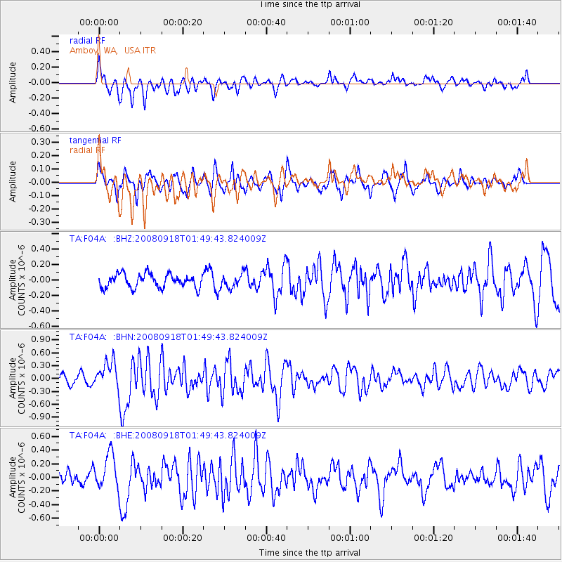
Signal To Noise
| Channel | StoN | STA | LTA |
| TA:F04A: :BHN:20080918T01:49:43.824009Z | 2.9819002 | 3.3220644E-7 | 1.1140764E-7 |
| TA:F04A: :BHE:20080918T01:49:43.824009Z | 2.6576617 | 2.6977102E-7 | 1.01506906E-7 |
| TA:F04A: :BHZ:20080918T01:49:43.824009Z | 1.0032707 | 8.734495E-8 | 8.70602E-8 |
| Arrivals |
| Ps | |
| PpPs | |
| PsPs/PpSs | |


