You are here: Home > Network List > WY - Yellowstone Wyoming Seismic Network Stations List
> Station YHL Hebgen Lake, YNP, WY, USA > Earthquake Result Viewer
YHL Hebgen Lake, YNP, WY, USA - Earthquake Result Viewer
| Earthquake location: |
Solomon Islands |
| Earthquake latitude/longitude: |
-8.9/158.4 |
| Earthquake time(UTC): |
2015/11/18 (322) 18:31:04 GMT |
| Earthquake Depth: |
11 km |
| Earthquake Magnitude: |
6.8 MWB, 7.0 MI |
| Earthquake Catalog/Contributor: |
NEIC PDE/NEIC COMCAT |
|
| Network: |
WY Yellowstone Wyoming Seismic Network |
| Station: |
YHL Hebgen Lake, YNP, WY, USA |
| Lat/Lon: |
44.85 N/111.18 W |
| Elevation: |
2691 m |
|
| Distance: |
96.5 deg |
| Az: |
45.718 deg |
| Baz: |
263.929 deg |
| Ray Param: |
0.04049229 |
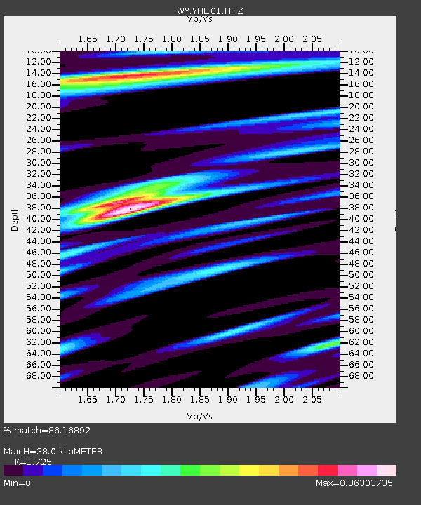
| Estimated Moho Depth: |
38.0 km |
| Estimated Crust Vp/Vs: |
1.73 |
| Assumed Crust Vp: |
6.35 km/s |
| Estimated Crust Vs: |
3.681 km/s |
| Estimated Crust Poisson's Ratio: |
0.25 |
|
| Radial Match: |
86.16892 % |
| Radial Bump: |
400 |
| Transverse Match: |
79.80564 % |
| Transverse Bump: |
400 |
| SOD ConfigId: |
1259291 |
| Insert Time: |
2015-12-02 19:23:18.010 +0000 |
| GWidth: |
2.5 |
| Max Bumps: |
400 |
| Tol: |
0.001 |
|

Signal To Noise
| Channel | StoN | STA | LTA |
| WY:YHL:01:HHZ:20151118T18:44:02.007998Z | 2.9481232 | 1.4533114E-8 | 4.929616E-9 |
| WY:YHL:01:HHN:20151118T18:44:02.007998Z | 1.6129167 | 1.1798219E-8 | 7.314835E-9 |
| WY:YHL:01:HHE:20151118T18:44:02.007998Z | 0.5687618 | 3.2946246E-9 | 5.792626E-9 |
| Arrivals |
| Ps | 4.4 SECOND |
| PpPs | 16 SECOND |
| PsPs/PpSs | 20 SECOND |


