You are here: Home > Network List > TA - USArray Transportable Network (new EarthScope stations) Stations List
> Station F04A Amboy, WA, USA > Earthquake Result Viewer
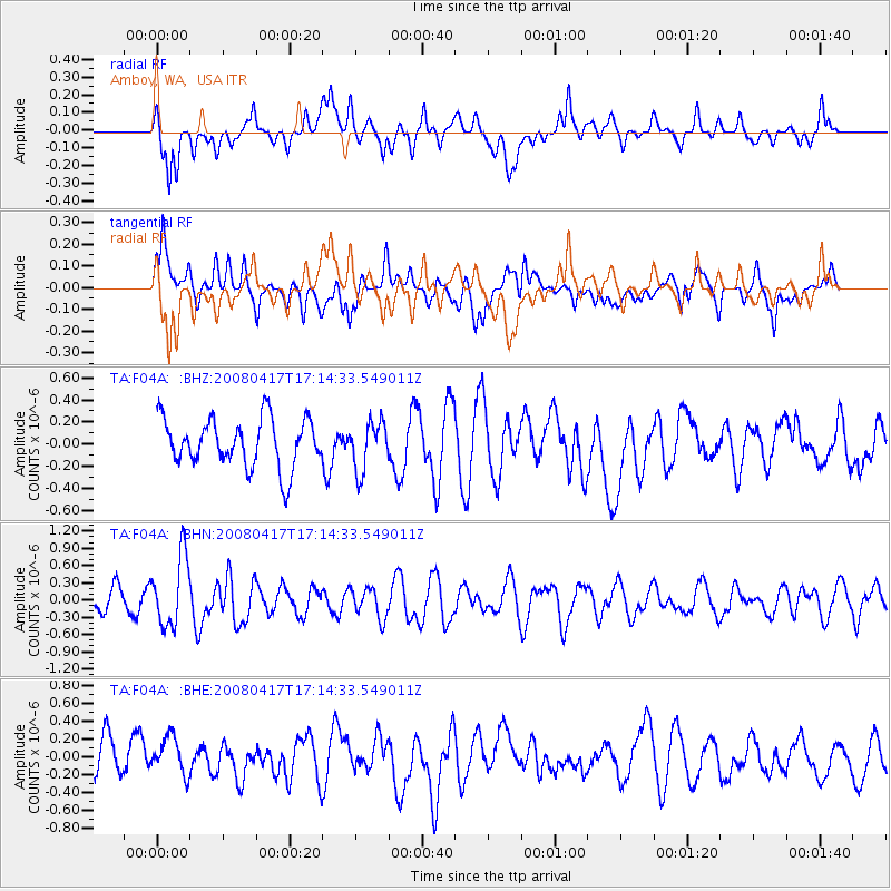
F04A Amboy, WA, USA - Earthquake Result Viewer
*The percent match for this event was below the threshold and hence no stack was calculated.
| Earthquake location: |
Mariana Islands Region |
| Earthquake latitude/longitude: |
15.9/144.9 |
| Earthquake time(UTC): |
2008/04/17 (108) 17:02:52 GMT |
| Earthquake Depth: |
10 km |
| Earthquake Magnitude: |
5.5 MB, 5.2 MS, 5.5 MW, 5.5 MW |
| Earthquake Catalog/Contributor: |
WHDF/NEIC |
|
| Network: |
TA USArray Transportable Network (new EarthScope stations) |
| Station: |
F04A Amboy, WA, USA |
| Lat/Lon: |
45.93 N/122.42 W |
| Elevation: |
211 m |
|
| Distance: |
80.6 deg |
| Az: |
44.959 deg |
| Baz: |
283.024 deg |
| Ray Param: |
$rayparam |
*The percent match for this event was below the threshold and hence was not used in the summary stack. |
|
| Radial Match: |
52.354454 % |
| Radial Bump: |
400 |
| Transverse Match: |
46.89698 % |
| Transverse Bump: |
400 |
| SOD ConfigId: |
2504 |
| Insert Time: |
2010-03-05 22:42:15.221 +0000 |
| GWidth: |
2.5 |
| Max Bumps: |
400 |
| Tol: |
0.001 |
|
Signal To Noise
| Channel | StoN | STA | LTA |
| TA:F04A: :BHN:20080417T17:14:33.549011Z | 3.7487206 | 6.062164E-7 | 1.6171288E-7 |
| TA:F04A: :BHE:20080417T17:14:33.549011Z | 1.1919482 | 2.0821936E-7 | 1.7468827E-7 |
| TA:F04A: :BHZ:20080417T17:14:33.549011Z | 0.99688846 | 2.184217E-7 | 2.1910346E-7 |
| Arrivals |
| Ps | |
| PpPs | |
| PsPs/PpSs | |


