You are here: Home > Network List > RV - Regional Alberta Seismic Observatory for Earthquake Studies Network Stations List
> Station EGLEA Eagle Lookout Tower, AB > Earthquake Result Viewer
EGLEA Eagle Lookout Tower, AB - Earthquake Result Viewer
| Earthquake location: |
Near East Coast Of Kamchatka |
| Earthquake latitude/longitude: |
56.9/162.7 |
| Earthquake time(UTC): |
2017/03/29 (088) 04:09:24 GMT |
| Earthquake Depth: |
23 km |
| Earthquake Magnitude: |
6.6 Mww |
| Earthquake Catalog/Contributor: |
NEIC PDE/us |
|
| Network: |
RV Regional Alberta Seismic Observatory for Earthquake Studies Network |
| Station: |
EGLEA Eagle Lookout Tower, AB |
| Lat/Lon: |
54.46 N/116.44 W |
| Elevation: |
1056 m |
|
| Distance: |
43.1 deg |
| Az: |
57.492 deg |
| Baz: |
307.626 deg |
| Ray Param: |
0.072721235 |
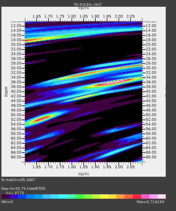
| Estimated Moho Depth: |
35.75 km |
| Estimated Crust Vp/Vs: |
1.98 |
| Assumed Crust Vp: |
6.426 km/s |
| Estimated Crust Vs: |
3.25 km/s |
| Estimated Crust Poisson's Ratio: |
0.33 |
|
| Radial Match: |
85.3687 % |
| Radial Bump: |
268 |
| Transverse Match: |
62.054893 % |
| Transverse Bump: |
400 |
| SOD ConfigId: |
11737051 |
| Insert Time: |
2019-04-27 00:29:03.161 +0000 |
| GWidth: |
2.5 |
| Max Bumps: |
400 |
| Tol: |
0.001 |
|

Signal To Noise
| Channel | StoN | STA | LTA |
| RV:EGLEA: :HHZ:20170329T04:16:52.330Z | 16.508827 | 7.3476554E-6 | 4.4507433E-7 |
| RV:EGLEA: :HHN:20170329T04:16:52.330Z | 3.4599025 | 2.411419E-6 | 6.969616E-7 |
| RV:EGLEA: :HHE:20170329T04:16:52.330Z | 3.629564 | 3.1119525E-6 | 8.573902E-7 |
| Arrivals |
| Ps | 5.8 SECOND |
| PpPs | 16 SECOND |
| PsPs/PpSs | 21 SECOND |


