You are here: Home > Network List > RV - Regional Alberta Seismic Observatory for Earthquake Studies Network Stations List
> Station STPRA Salt Prairie Lookout Tower, AB > Earthquake Result Viewer
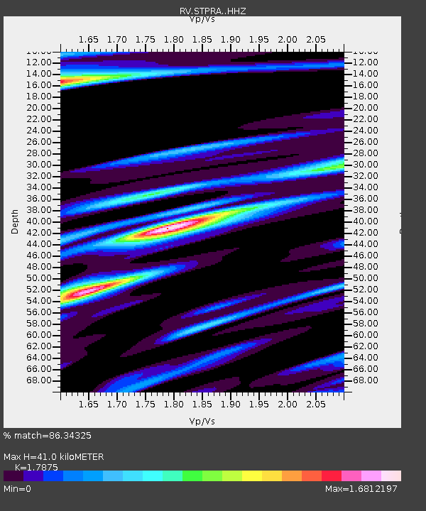
STPRA Salt Prairie Lookout Tower, AB - Earthquake Result Viewer
| Earthquake location: |
Near East Coast Of Kamchatka |
| Earthquake latitude/longitude: |
56.9/162.7 |
| Earthquake time(UTC): |
2017/03/29 (088) 04:09:24 GMT |
| Earthquake Depth: |
23 km |
| Earthquake Magnitude: |
6.6 Mww |
| Earthquake Catalog/Contributor: |
NEIC PDE/us |
|
| Network: |
RV Regional Alberta Seismic Observatory for Earthquake Studies Network |
| Station: |
STPRA Salt Prairie Lookout Tower, AB |
| Lat/Lon: |
55.66 N/115.83 W |
| Elevation: |
761 m |
|
| Distance: |
42.7 deg |
| Az: |
55.77 deg |
| Baz: |
306.862 deg |
| Ray Param: |
0.073005244 |
| Estimated Moho Depth: |
41.0 km |
| Estimated Crust Vp/Vs: |
1.79 |
| Assumed Crust Vp: |
6.483 km/s |
| Estimated Crust Vs: |
3.627 km/s |
| Estimated Crust Poisson's Ratio: |
0.27 |
|
| Radial Match: |
86.34325 % |
| Radial Bump: |
400 |
| Transverse Match: |
68.20664 % |
| Transverse Bump: |
400 |
| SOD ConfigId: |
11737051 |
| Insert Time: |
2019-04-27 00:29:10.427 +0000 |
| GWidth: |
2.5 |
| Max Bumps: |
400 |
| Tol: |
0.001 |
|

Signal To Noise
| Channel | StoN | STA | LTA |
| RV:STPRA: :HHZ:20170329T04:16:48.669996Z | 28.94891 | 8.005652E-6 | 2.765441E-7 |
| RV:STPRA: :HHN:20170329T04:16:48.669996Z | 6.874261 | 3.975676E-6 | 5.7834234E-7 |
| RV:STPRA: :HHE:20170329T04:16:48.669996Z | 10.91646 | 5.017279E-6 | 4.5960675E-7 |
| Arrivals |
| Ps | 5.3 SECOND |
| PpPs | 16 SECOND |
| PsPs/PpSs | 22 SECOND |


