You are here: Home > Network List > RV - Regional Alberta Seismic Observatory for Earthquake Studies Network Stations List
> Station WAPA Wapiti River, AB > Earthquake Result Viewer
WAPA Wapiti River, AB - Earthquake Result Viewer
| Earthquake location: |
Near East Coast Of Kamchatka |
| Earthquake latitude/longitude: |
56.9/162.7 |
| Earthquake time(UTC): |
2017/03/29 (088) 04:09:24 GMT |
| Earthquake Depth: |
23 km |
| Earthquake Magnitude: |
6.6 Mww |
| Earthquake Catalog/Contributor: |
NEIC PDE/us |
|
| Network: |
RV Regional Alberta Seismic Observatory for Earthquake Studies Network |
| Station: |
WAPA Wapiti River, AB |
| Lat/Lon: |
55.18 N/119.25 W |
| Elevation: |
784 m |
|
| Distance: |
41.4 deg |
| Az: |
58.071 deg |
| Baz: |
305.76 deg |
| Ray Param: |
0.07379309 |
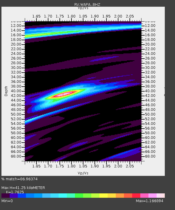
| Estimated Moho Depth: |
41.25 km |
| Estimated Crust Vp/Vs: |
1.76 |
| Assumed Crust Vp: |
6.161 km/s |
| Estimated Crust Vs: |
3.496 km/s |
| Estimated Crust Poisson's Ratio: |
0.26 |
|
| Radial Match: |
86.96374 % |
| Radial Bump: |
302 |
| Transverse Match: |
71.073784 % |
| Transverse Bump: |
400 |
| SOD ConfigId: |
11737051 |
| Insert Time: |
2019-04-27 00:29:10.890 +0000 |
| GWidth: |
2.5 |
| Max Bumps: |
400 |
| Tol: |
0.001 |
|

Signal To Noise
| Channel | StoN | STA | LTA |
| RV:WAPA: :BHZ:20170329T04:16:38.175001Z | 17.989498 | 6.048927E-6 | 3.3624767E-7 |
| RV:WAPA: :BHN:20170329T04:16:38.175001Z | 2.5638545 | 9.578953E-7 | 3.7361534E-7 |
| RV:WAPA: :BHE:20170329T04:16:38.175001Z | 6.225622 | 3.703363E-6 | 5.948583E-7 |
| Arrivals |
| Ps | 5.4 SECOND |
| PpPs | 17 SECOND |
| PsPs/PpSs | 23 SECOND |


