You are here: Home > Network List > SC - New Mexico Tech Seismic Network Stations List
> Station Y22A Socorro, NM, USA > Earthquake Result Viewer
Y22A Socorro, NM, USA - Earthquake Result Viewer
| Earthquake location: |
Near East Coast Of Kamchatka |
| Earthquake latitude/longitude: |
56.9/162.7 |
| Earthquake time(UTC): |
2017/03/29 (088) 04:09:24 GMT |
| Earthquake Depth: |
23 km |
| Earthquake Magnitude: |
6.6 Mww |
| Earthquake Catalog/Contributor: |
NEIC PDE/us |
|
| Network: |
SC New Mexico Tech Seismic Network |
| Station: |
Y22A Socorro, NM, USA |
| Lat/Lon: |
33.94 N/106.97 W |
| Elevation: |
1674 m |
|
| Distance: |
62.5 deg |
| Az: |
69.649 deg |
| Baz: |
321.799 deg |
| Ray Param: |
0.060179222 |
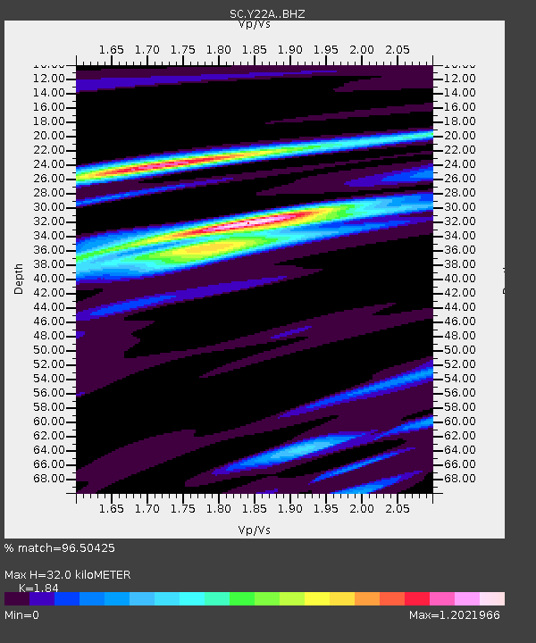
| Estimated Moho Depth: |
32.0 km |
| Estimated Crust Vp/Vs: |
1.84 |
| Assumed Crust Vp: |
6.502 km/s |
| Estimated Crust Vs: |
3.533 km/s |
| Estimated Crust Poisson's Ratio: |
0.29 |
|
| Radial Match: |
96.50425 % |
| Radial Bump: |
334 |
| Transverse Match: |
90.877525 % |
| Transverse Bump: |
400 |
| SOD ConfigId: |
11737051 |
| Insert Time: |
2019-04-27 00:29:11.867 +0000 |
| GWidth: |
2.5 |
| Max Bumps: |
400 |
| Tol: |
0.001 |
|

Signal To Noise
| Channel | StoN | STA | LTA |
| SC:Y22A: :BHZ:20170329T04:19:15.074019Z | 24.973621 | 3.7126765E-6 | 1.4866393E-7 |
| SC:Y22A: :BHN:20170329T04:19:15.074019Z | 9.99937 | 1.2768083E-6 | 1.2768889E-7 |
| SC:Y22A: :BHE:20170329T04:19:15.074019Z | 4.9455705 | 1.4052433E-6 | 2.841418E-7 |
| Arrivals |
| Ps | 4.3 SECOND |
| PpPs | 13 SECOND |
| PsPs/PpSs | 18 SECOND |


