You are here: Home > Network List > TA - USArray Transportable Network (new EarthScope stations) Stations List
> Station F04A Amboy, WA, USA > Earthquake Result Viewer
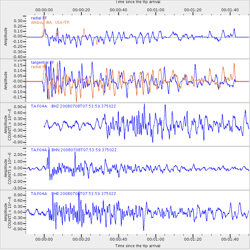
F04A Amboy, WA, USA - Earthquake Result Viewer
*The percent match for this event was below the threshold and hence no stack was calculated.
| Earthquake location: |
Ryukyu Islands, Japan |
| Earthquake latitude/longitude: |
27.5/128.3 |
| Earthquake time(UTC): |
2008/07/08 (190) 07:42:10 GMT |
| Earthquake Depth: |
43 km |
| Earthquake Magnitude: |
6.0 MB, 5.5 MS, 6.0 MW, 6.0 MW |
| Earthquake Catalog/Contributor: |
WHDF/NEIC |
|
| Network: |
TA USArray Transportable Network (new EarthScope stations) |
| Station: |
F04A Amboy, WA, USA |
| Lat/Lon: |
45.93 N/122.42 W |
| Elevation: |
211 m |
|
| Distance: |
82.8 deg |
| Az: |
41.614 deg |
| Baz: |
302.326 deg |
| Ray Param: |
$rayparam |
*The percent match for this event was below the threshold and hence was not used in the summary stack. |
|
| Radial Match: |
67.328064 % |
| Radial Bump: |
400 |
| Transverse Match: |
55.96702 % |
| Transverse Bump: |
400 |
| SOD ConfigId: |
2504 |
| Insert Time: |
2010-03-05 22:42:27.343 +0000 |
| GWidth: |
2.5 |
| Max Bumps: |
400 |
| Tol: |
0.001 |
|
Signal To Noise
| Channel | StoN | STA | LTA |
| TA:F04A: :BHN:20080708T07:53:59.37502Z | 6.421013 | 1.036581E-6 | 1.6143574E-7 |
| TA:F04A: :BHE:20080708T07:53:59.37502Z | 1.1011341 | 2.506977E-7 | 2.2767226E-7 |
| TA:F04A: :BHZ:20080708T07:53:59.37502Z | 2.3787284 | 2.8599084E-7 | 1.2022845E-7 |
| Arrivals |
| Ps | |
| PpPs | |
| PsPs/PpSs | |


