You are here: Home > Network List > TA - USArray Transportable Network (new EarthScope stations) Stations List
> Station M31M Drury Creek, Yukon, CA > Earthquake Result Viewer
M31M Drury Creek, Yukon, CA - Earthquake Result Viewer
| Earthquake location: |
Near East Coast Of Kamchatka |
| Earthquake latitude/longitude: |
56.9/162.7 |
| Earthquake time(UTC): |
2017/03/29 (088) 04:09:24 GMT |
| Earthquake Depth: |
23 km |
| Earthquake Magnitude: |
6.6 Mww |
| Earthquake Catalog/Contributor: |
NEIC PDE/us |
|
| Network: |
TA USArray Transportable Network (new EarthScope stations) |
| Station: |
M31M Drury Creek, Yukon, CA |
| Lat/Lon: |
62.20 N/134.39 W |
| Elevation: |
639 m |
|
| Distance: |
31.1 deg |
| Az: |
53.776 deg |
| Baz: |
289.328 deg |
| Ray Param: |
0.079129845 |
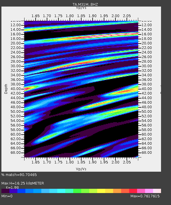
| Estimated Moho Depth: |
16.25 km |
| Estimated Crust Vp/Vs: |
1.98 |
| Assumed Crust Vp: |
6.419 km/s |
| Estimated Crust Vs: |
3.242 km/s |
| Estimated Crust Poisson's Ratio: |
0.33 |
|
| Radial Match: |
90.70465 % |
| Radial Bump: |
400 |
| Transverse Match: |
72.50875 % |
| Transverse Bump: |
400 |
| SOD ConfigId: |
11737051 |
| Insert Time: |
2019-04-27 00:29:40.419 +0000 |
| GWidth: |
2.5 |
| Max Bumps: |
400 |
| Tol: |
0.001 |
|

Signal To Noise
| Channel | StoN | STA | LTA |
| TA:M31M: :BHZ:20170329T04:15:10.974989Z | 16.787704 | 6.5351787E-6 | 3.8928366E-7 |
| TA:M31M: :BHN:20170329T04:15:10.974989Z | 5.269178 | 1.5799344E-6 | 2.9984457E-7 |
| TA:M31M: :BHE:20170329T04:15:10.974989Z | 16.184776 | 3.9334573E-6 | 2.4303438E-7 |
| Arrivals |
| Ps | 2.7 SECOND |
| PpPs | 7.0 SECOND |
| PsPs/PpSs | 9.7 SECOND |


