You are here: Home > Network List > TA - USArray Transportable Network (new EarthScope stations) Stations List
> Station O48B Farmland, IN, USA > Earthquake Result Viewer
O48B Farmland, IN, USA - Earthquake Result Viewer
| Earthquake location: |
Near East Coast Of Kamchatka |
| Earthquake latitude/longitude: |
56.9/162.7 |
| Earthquake time(UTC): |
2017/03/29 (088) 04:09:24 GMT |
| Earthquake Depth: |
23 km |
| Earthquake Magnitude: |
6.6 Mww |
| Earthquake Catalog/Contributor: |
NEIC PDE/us |
|
| Network: |
TA USArray Transportable Network (new EarthScope stations) |
| Station: |
O48B Farmland, IN, USA |
| Lat/Lon: |
40.26 N/85.16 W |
| Elevation: |
300 m |
|
| Distance: |
67.6 deg |
| Az: |
50.051 deg |
| Baz: |
326.679 deg |
| Ray Param: |
0.056792974 |
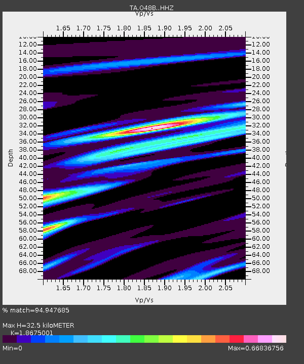
| Estimated Moho Depth: |
32.5 km |
| Estimated Crust Vp/Vs: |
1.87 |
| Assumed Crust Vp: |
6.498 km/s |
| Estimated Crust Vs: |
3.479 km/s |
| Estimated Crust Poisson's Ratio: |
0.30 |
|
| Radial Match: |
94.947685 % |
| Radial Bump: |
280 |
| Transverse Match: |
75.40443 % |
| Transverse Bump: |
400 |
| SOD ConfigId: |
11737051 |
| Insert Time: |
2019-04-27 00:29:45.703 +0000 |
| GWidth: |
2.5 |
| Max Bumps: |
400 |
| Tol: |
0.001 |
|

Signal To Noise
| Channel | StoN | STA | LTA |
| TA:O48B: :HHZ:20170329T04:19:48.670027Z | 15.905251 | 4.217656E-6 | 2.6517384E-7 |
| TA:O48B: :HHN:20170329T04:19:48.670027Z | 7.455732 | 1.7793934E-6 | 2.3866113E-7 |
| TA:O48B: :HHE:20170329T04:19:48.670027Z | 13.443741 | 1.359659E-6 | 1.0113695E-7 |
| Arrivals |
| Ps | 4.5 SECOND |
| PpPs | 14 SECOND |
| PsPs/PpSs | 18 SECOND |


