You are here: Home > Network List > TA - USArray Transportable Network (new EarthScope stations) Stations List
> Station T33K Petersburg, AK, USA > Earthquake Result Viewer
T33K Petersburg, AK, USA - Earthquake Result Viewer
| Earthquake location: |
Near East Coast Of Kamchatka |
| Earthquake latitude/longitude: |
56.9/162.7 |
| Earthquake time(UTC): |
2017/03/29 (088) 04:09:24 GMT |
| Earthquake Depth: |
23 km |
| Earthquake Magnitude: |
6.6 Mww |
| Earthquake Catalog/Contributor: |
NEIC PDE/us |
|
| Network: |
TA USArray Transportable Network (new EarthScope stations) |
| Station: |
T33K Petersburg, AK, USA |
| Lat/Lon: |
56.81 N/132.95 W |
| Elevation: |
22 m |
|
| Distance: |
34.0 deg |
| Az: |
62.437 deg |
| Baz: |
297.872 deg |
| Ray Param: |
0.07792573 |
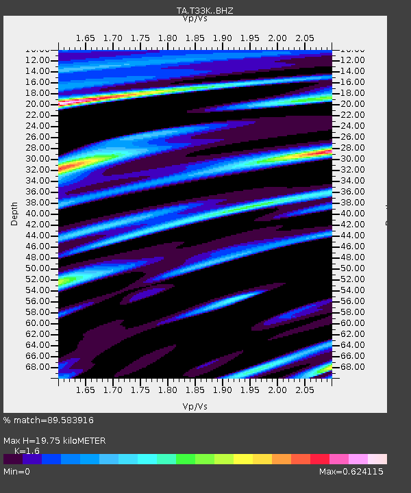
| Estimated Moho Depth: |
19.75 km |
| Estimated Crust Vp/Vs: |
1.60 |
| Assumed Crust Vp: |
6.597 km/s |
| Estimated Crust Vs: |
4.123 km/s |
| Estimated Crust Poisson's Ratio: |
0.18 |
|
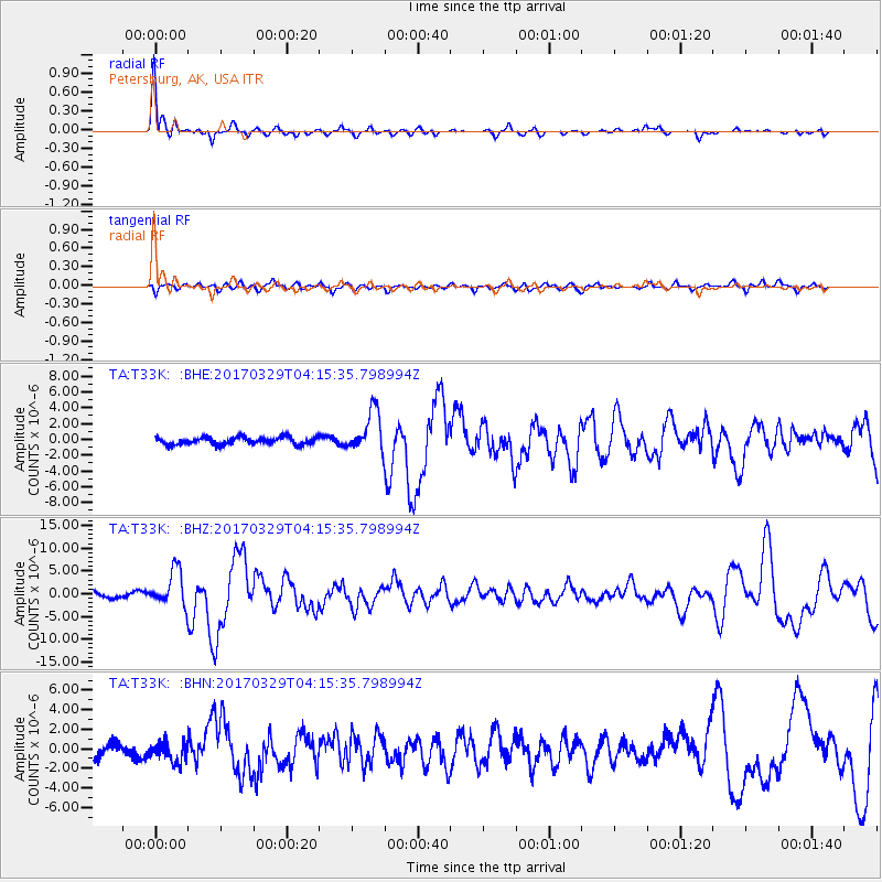
| Radial Match: |
89.583916 % |
| Radial Bump: |
313 |
| Transverse Match: |
67.09422 % |
| Transverse Bump: |
400 |
| SOD ConfigId: |
11737051 |
| Insert Time: |
2019-04-27 00:30:02.526 +0000 |
| GWidth: |
2.5 |
| Max Bumps: |
400 |
| Tol: |
0.001 |
|
Signal To Noise
| Channel | StoN | STA | LTA |
| TA:T33K: :BHZ:20170329T04:15:35.798994Z | 6.8234253 | 3.917112E-6 | 5.740683E-7 |
| TA:T33K: :BHN:20170329T04:15:35.798994Z | 1.3335232 | 9.929397E-7 | 7.445988E-7 |
| TA:T33K: :BHE:20170329T04:15:35.798994Z | 5.912001 | 2.7290014E-6 | 4.6160366E-7 |
| Arrivals |
| Ps | 2.0 SECOND |
| PpPs | 7.1 SECOND |
| PsPs/PpSs | 9.1 SECOND |


