You are here: Home > Network List > TA - USArray Transportable Network (new EarthScope stations) Stations List
> Station V35K Ketchikan, AK, USA > Earthquake Result Viewer
V35K Ketchikan, AK, USA - Earthquake Result Viewer
| Earthquake location: |
Near East Coast Of Kamchatka |
| Earthquake latitude/longitude: |
56.9/162.7 |
| Earthquake time(UTC): |
2017/03/29 (088) 04:09:24 GMT |
| Earthquake Depth: |
23 km |
| Earthquake Magnitude: |
6.6 Mww |
| Earthquake Catalog/Contributor: |
NEIC PDE/us |
|
| Network: |
TA USArray Transportable Network (new EarthScope stations) |
| Station: |
V35K Ketchikan, AK, USA |
| Lat/Lon: |
55.33 N/131.62 W |
| Elevation: |
64 m |
|
| Distance: |
35.4 deg |
| Az: |
64.084 deg |
| Baz: |
300.334 deg |
| Ray Param: |
0.077228144 |
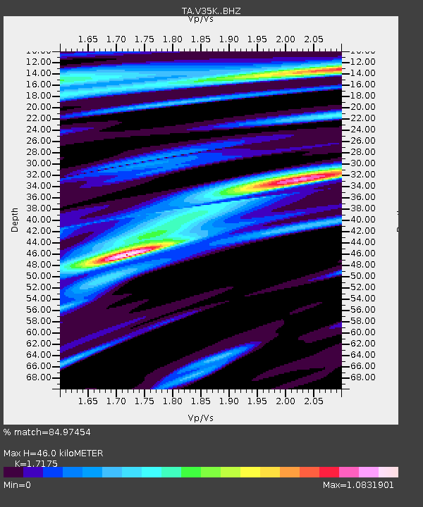
| Estimated Moho Depth: |
46.0 km |
| Estimated Crust Vp/Vs: |
1.72 |
| Assumed Crust Vp: |
6.545 km/s |
| Estimated Crust Vs: |
3.811 km/s |
| Estimated Crust Poisson's Ratio: |
0.24 |
|
| Radial Match: |
84.97454 % |
| Radial Bump: |
391 |
| Transverse Match: |
56.550213 % |
| Transverse Bump: |
393 |
| SOD ConfigId: |
11737051 |
| Insert Time: |
2019-04-27 00:30:06.828 +0000 |
| GWidth: |
2.5 |
| Max Bumps: |
400 |
| Tol: |
0.001 |
|
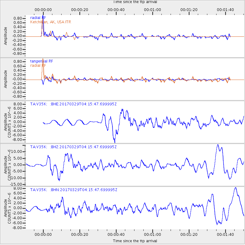
Signal To Noise
| Channel | StoN | STA | LTA |
| TA:V35K: :BHZ:20170329T04:15:47.699995Z | 5.278345 | 3.6929928E-6 | 6.996497E-7 |
| TA:V35K: :BHN:20170329T04:15:47.699995Z | 0.8580028 | 6.417648E-7 | 7.479752E-7 |
| TA:V35K: :BHE:20170329T04:15:47.699995Z | 2.2465365 | 1.8526805E-6 | 8.24683E-7 |
| Arrivals |
| Ps | 5.5 SECOND |
| PpPs | 18 SECOND |
| PsPs/PpSs | 23 SECOND |


