You are here: Home > Network List > TA - USArray Transportable Network (new EarthScope stations) Stations List
> Station N15A Stansbury Island BLM, Grantsville, UT, USA > Earthquake Result Viewer
N15A Stansbury Island BLM, Grantsville, UT, USA - Earthquake Result Viewer
| Earthquake location: |
Costa Rica |
| Earthquake latitude/longitude: |
10.2/-84.2 |
| Earthquake time(UTC): |
2009/01/08 (008) 19:21:35 GMT |
| Earthquake Depth: |
14 km |
| Earthquake Magnitude: |
5.7 MB, 6.0 MS, 6.1 MW, 6.1 MW |
| Earthquake Catalog/Contributor: |
WHDF/NEIC |
|
| Network: |
TA USArray Transportable Network (new EarthScope stations) |
| Station: |
N15A Stansbury Island BLM, Grantsville, UT, USA |
| Lat/Lon: |
40.89 N/112.52 W |
| Elevation: |
1408 m |
|
| Distance: |
39.5 deg |
| Az: |
325.583 deg |
| Baz: |
132.779 deg |
| Ray Param: |
0.07492538 |
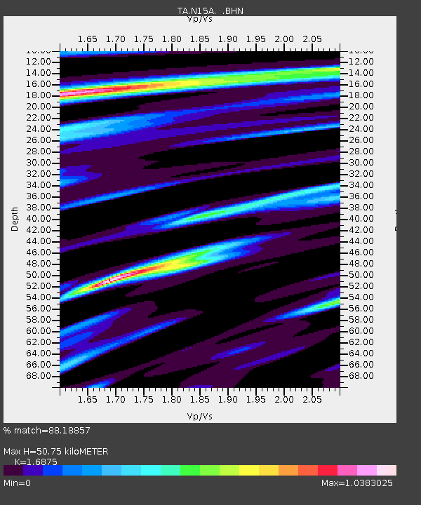
| Estimated Moho Depth: |
50.75 km |
| Estimated Crust Vp/Vs: |
1.69 |
| Assumed Crust Vp: |
6.276 km/s |
| Estimated Crust Vs: |
3.719 km/s |
| Estimated Crust Poisson's Ratio: |
0.23 |
|
| Radial Match: |
88.18857 % |
| Radial Bump: |
400 |
| Transverse Match: |
59.4008 % |
| Transverse Bump: |
400 |
| SOD ConfigId: |
2834 |
| Insert Time: |
2010-03-05 22:42:36.970 +0000 |
| GWidth: |
2.5 |
| Max Bumps: |
400 |
| Tol: |
0.001 |
|

Signal To Noise
| Channel | StoN | STA | LTA |
| TA:N15A: :BHN:20090108T19:28:35.000015Z | 2.7145364 | 3.8319897E-7 | 1.4116553E-7 |
| TA:N15A: :BHE:20090108T19:28:35.000015Z | 1.400764 | 2.1969086E-7 | 1.5683645E-7 |
| TA:N15A: :BHZ:20090108T19:28:35.000015Z | 1.4786614 | 3.2967571E-7 | 2.229555E-7 |
| Arrivals |
| Ps | 6.0 SECOND |
| PpPs | 20 SECOND |
| PsPs/PpSs | 26 SECOND |


