You are here: Home > Network List > UO - University of Oregon Regional Network Stations List
> Station DRAN Drain, OR, USA > Earthquake Result Viewer
DRAN Drain, OR, USA - Earthquake Result Viewer
| Earthquake location: |
Near East Coast Of Kamchatka |
| Earthquake latitude/longitude: |
56.9/162.7 |
| Earthquake time(UTC): |
2017/03/29 (088) 04:09:24 GMT |
| Earthquake Depth: |
23 km |
| Earthquake Magnitude: |
6.6 Mww |
| Earthquake Catalog/Contributor: |
NEIC PDE/us |
|
| Network: |
UO University of Oregon Regional Network |
| Station: |
DRAN Drain, OR, USA |
| Lat/Lon: |
43.70 N/123.35 W |
| Elevation: |
141 m |
|
| Distance: |
46.7 deg |
| Az: |
73.27 deg |
| Baz: |
313.61 deg |
| Ray Param: |
0.07044799 |
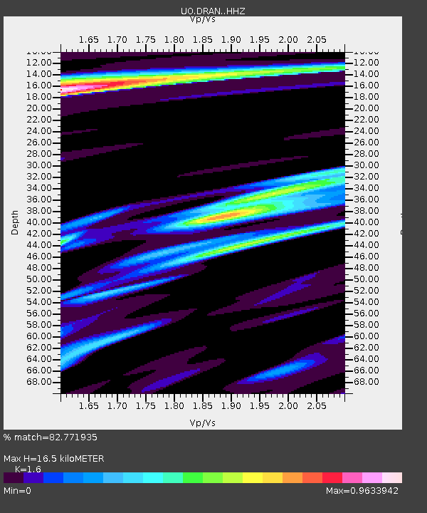
| Estimated Moho Depth: |
16.5 km |
| Estimated Crust Vp/Vs: |
1.60 |
| Assumed Crust Vp: |
6.522 km/s |
| Estimated Crust Vs: |
4.076 km/s |
| Estimated Crust Poisson's Ratio: |
0.18 |
|
| Radial Match: |
82.771935 % |
| Radial Bump: |
355 |
| Transverse Match: |
66.93414 % |
| Transverse Bump: |
400 |
| SOD ConfigId: |
11737051 |
| Insert Time: |
2019-04-27 00:30:46.798 +0000 |
| GWidth: |
2.5 |
| Max Bumps: |
400 |
| Tol: |
0.001 |
|

Signal To Noise
| Channel | StoN | STA | LTA |
| UO:DRAN: :HHZ:20170329T04:17:20.777998Z | 7.891937 | 4.369374E-6 | 5.5365035E-7 |
| UO:DRAN: :HHN:20170329T04:17:20.777998Z | 1.4743366 | 1.0488019E-6 | 7.11372E-7 |
| UO:DRAN: :HHE:20170329T04:17:20.777998Z | 2.616297 | 1.6749182E-6 | 6.4018656E-7 |
| Arrivals |
| Ps | 1.6 SECOND |
| PpPs | 6.1 SECOND |
| PsPs/PpSs | 7.8 SECOND |


