You are here: Home > Network List > UO - University of Oregon Regional Network Stations List
> Station TOOM Fort Rock, OR, USA > Earthquake Result Viewer
TOOM Fort Rock, OR, USA - Earthquake Result Viewer
| Earthquake location: |
Near East Coast Of Kamchatka |
| Earthquake latitude/longitude: |
56.9/162.7 |
| Earthquake time(UTC): |
2017/03/29 (088) 04:09:24 GMT |
| Earthquake Depth: |
23 km |
| Earthquake Magnitude: |
6.6 Mww |
| Earthquake Catalog/Contributor: |
NEIC PDE/us |
|
| Network: |
UO University of Oregon Regional Network |
| Station: |
TOOM Fort Rock, OR, USA |
| Lat/Lon: |
43.28 N/121.23 W |
| Elevation: |
1541 m |
|
| Distance: |
48.1 deg |
| Az: |
72.221 deg |
| Baz: |
314.35 deg |
| Ray Param: |
0.069547355 |
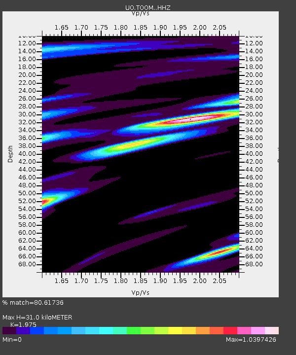
| Estimated Moho Depth: |
31.0 km |
| Estimated Crust Vp/Vs: |
1.98 |
| Assumed Crust Vp: |
6.597 km/s |
| Estimated Crust Vs: |
3.341 km/s |
| Estimated Crust Poisson's Ratio: |
0.33 |
|
| Radial Match: |
80.61736 % |
| Radial Bump: |
400 |
| Transverse Match: |
79.2836 % |
| Transverse Bump: |
400 |
| SOD ConfigId: |
11737051 |
| Insert Time: |
2019-04-27 00:30:54.396 +0000 |
| GWidth: |
2.5 |
| Max Bumps: |
400 |
| Tol: |
0.001 |
|

Signal To Noise
| Channel | StoN | STA | LTA |
| UO:TOOM: :HHZ:20170329T04:17:31.598005Z | 8.128504 | 5.1993634E-6 | 6.396458E-7 |
| UO:TOOM: :HHN:20170329T04:17:31.598005Z | 3.5548139 | 1.500178E-6 | 4.2201307E-7 |
| UO:TOOM: :HHE:20170329T04:17:31.598005Z | 2.5600555 | 2.0473328E-6 | 7.9972205E-7 |
| Arrivals |
| Ps | 4.9 SECOND |
| PpPs | 13 SECOND |
| PsPs/PpSs | 18 SECOND |


