You are here: Home > Network List > GS - US Geological Survey Networks Stations List
> Station KAN13 Rinehart Farm, , CA, USA > Earthquake Result Viewer
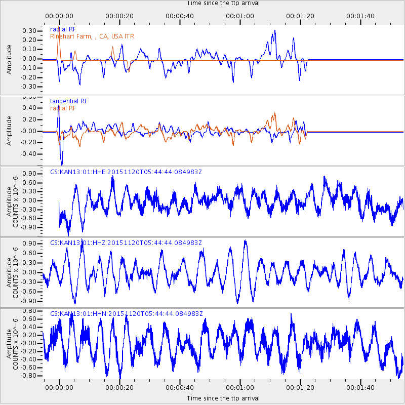
KAN13 Rinehart Farm, , CA, USA - Earthquake Result Viewer
*The percent match for this event was below the threshold and hence no stack was calculated.
| Earthquake location: |
Bonin Islands, Japan Region |
| Earthquake latitude/longitude: |
26.4/142.7 |
| Earthquake time(UTC): |
2015/11/20 (324) 05:31:52 GMT |
| Earthquake Depth: |
13 km |
| Earthquake Magnitude: |
5.5 MB |
| Earthquake Catalog/Contributor: |
NEIC PDE/NEIC COMCAT |
|
| Network: |
GS US Geological Survey Networks |
| Station: |
KAN13 Rinehart Farm, , CA, USA |
| Lat/Lon: |
37.01 N/97.48 W |
| Elevation: |
340 m |
|
| Distance: |
95.3 deg |
| Az: |
44.222 deg |
| Baz: |
308.59 deg |
| Ray Param: |
$rayparam |
*The percent match for this event was below the threshold and hence was not used in the summary stack. |
|
| Radial Match: |
40.21763 % |
| Radial Bump: |
400 |
| Transverse Match: |
53.284668 % |
| Transverse Bump: |
400 |
| SOD ConfigId: |
1259291 |
| Insert Time: |
2015-12-04 06:25:00.272 +0000 |
| GWidth: |
2.5 |
| Max Bumps: |
400 |
| Tol: |
0.001 |
|
Signal To Noise
| Channel | StoN | STA | LTA |
| GS:KAN13:01:HHZ:20151120T05:44:44.084983Z | 1.3149217 | 4.1319103E-7 | 3.142324E-7 |
| GS:KAN13:01:HHN:20151120T05:44:44.084983Z | 1.6924759 | 4.88951E-7 | 2.8889687E-7 |
| GS:KAN13:01:HHE:20151120T05:44:44.084983Z | 0.6571095 | 2.671656E-7 | 4.06577E-7 |
| Arrivals |
| Ps | |
| PpPs | |
| PsPs/PpSs | |


