You are here: Home > Network List > UU - University of Utah Regional Network Stations List
> Station FOR3 Blundell North, UT, USA > Earthquake Result Viewer
FOR3 Blundell North, UT, USA - Earthquake Result Viewer
| Earthquake location: |
Near East Coast Of Kamchatka |
| Earthquake latitude/longitude: |
56.9/162.7 |
| Earthquake time(UTC): |
2017/03/29 (088) 04:09:24 GMT |
| Earthquake Depth: |
23 km |
| Earthquake Magnitude: |
6.6 Mww |
| Earthquake Catalog/Contributor: |
NEIC PDE/us |
|
| Network: |
UU University of Utah Regional Network |
| Station: |
FOR3 Blundell North, UT, USA |
| Lat/Lon: |
38.51 N/112.88 W |
| Elevation: |
1699 m |
|
| Distance: |
55.9 deg |
| Az: |
70.539 deg |
| Baz: |
318.77 deg |
| Ray Param: |
0.06446216 |
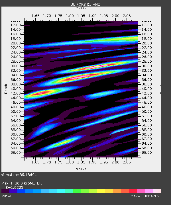
| Estimated Moho Depth: |
30.0 km |
| Estimated Crust Vp/Vs: |
1.92 |
| Assumed Crust Vp: |
6.276 km/s |
| Estimated Crust Vs: |
3.264 km/s |
| Estimated Crust Poisson's Ratio: |
0.31 |
|
| Radial Match: |
89.15604 % |
| Radial Bump: |
400 |
| Transverse Match: |
84.12636 % |
| Transverse Bump: |
400 |
| SOD ConfigId: |
11737051 |
| Insert Time: |
2019-04-27 00:31:04.475 +0000 |
| GWidth: |
2.5 |
| Max Bumps: |
400 |
| Tol: |
0.001 |
|

Signal To Noise
| Channel | StoN | STA | LTA |
| UU:FOR3:01:HHZ:20170329T04:18:29.668989Z | 12.282216 | 1.2212986E-7 | 9.943634E-9 |
| UU:FOR3:01:HHN:20170329T04:18:29.668989Z | 5.722882 | 6.995468E-8 | 1.2223681E-8 |
| UU:FOR3:01:HHE:20170329T04:18:29.668989Z | 5.976352 | 7.129757E-8 | 1.1929949E-8 |
| Arrivals |
| Ps | 4.6 SECOND |
| PpPs | 13 SECOND |
| PsPs/PpSs | 18 SECOND |


