You are here: Home > Network List > TA - USArray Transportable Network (new EarthScope stations) Stations List
> Station N15A Stansbury Island BLM, Grantsville, UT, USA > Earthquake Result Viewer
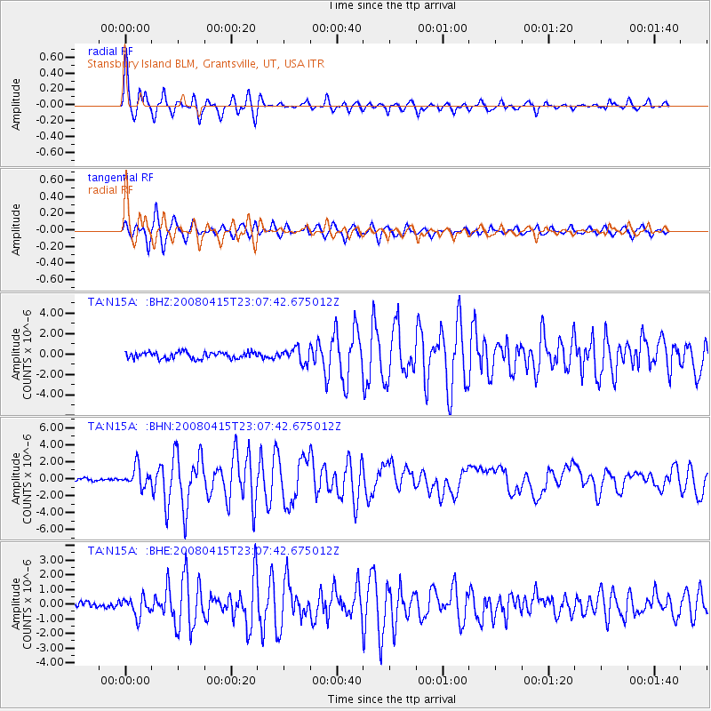
N15A Stansbury Island BLM, Grantsville, UT, USA - Earthquake Result Viewer

| Earthquake location: |
Andreanof Islands, Aleutian Is. |
| Earthquake latitude/longitude: |
51.9/-179.4 |
| Earthquake time(UTC): |
2008/04/15 (106) 22:59:51 GMT |
| Earthquake Depth: |
10 km |
| Earthquake Magnitude: |
6.1 MB, 6.4 MS, 6.4 MW, 6.4 MW |
| Earthquake Catalog/Contributor: |
WHDF/NEIC |
|
| Network: |
TA USArray Transportable Network (new EarthScope stations) |
| Station: |
N15A Stansbury Island BLM, Grantsville, UT, USA |
| Lat/Lon: |
40.89 N/112.52 W |
| Elevation: |
1408 m |
|
| Distance: |
45.9 deg |
| Az: |
76.252 deg |
| Baz: |
307.377 deg |
| Ray Param: |
0.071005225 |
| Estimated Moho Depth: |
22.75 km |
| Estimated Crust Vp/Vs: |
2.01 |
| Assumed Crust Vp: |
6.276 km/s |
| Estimated Crust Vs: |
3.126 km/s |
| Estimated Crust Poisson's Ratio: |
0.33 |
|
| Radial Match: |
91.26271 % |
| Radial Bump: |
400 |
| Transverse Match: |
89.054214 % |
| Transverse Bump: |
400 |
| SOD ConfigId: |
2504 |
| Insert Time: |
2010-03-05 22:42:47.575 +0000 |
| GWidth: |
2.5 |
| Max Bumps: |
400 |
| Tol: |
0.001 |
|
Signal To Noise
| Channel | StoN | STA | LTA |
| TA:N15A: :BHN:20080415T23:07:42.675012Z | 9.574093 | 1.1848128E-6 | 1.2375197E-7 |
| TA:N15A: :BHE:20080415T23:07:42.675012Z | 3.8690128 | 6.382519E-7 | 1.6496504E-7 |
| TA:N15A: :BHZ:20080415T23:07:42.675012Z | 2.2099156 | 7.0970486E-7 | 3.211457E-7 |
| Arrivals |
| Ps | 3.9 SECOND |
| PpPs | 10 SECOND |
| PsPs/PpSs | 14 SECOND |


