You are here: Home > Network List > UW - Pacific Northwest Regional Seismic Network Stations List
> Station LTY Liberty (broad-band) > Earthquake Result Viewer
LTY Liberty (broad-band) - Earthquake Result Viewer

| Earthquake location: |
Near East Coast Of Kamchatka |
| Earthquake latitude/longitude: |
56.9/162.7 |
| Earthquake time(UTC): |
2017/03/29 (088) 04:09:24 GMT |
| Earthquake Depth: |
23 km |
| Earthquake Magnitude: |
6.6 Mww |
| Earthquake Catalog/Contributor: |
NEIC PDE/us |
|
| Network: |
UW Pacific Northwest Regional Seismic Network |
| Station: |
LTY Liberty (broad-band) |
| Lat/Lon: |
47.26 N/120.66 W |
| Elevation: |
970 m |
|
| Distance: |
45.7 deg |
| Az: |
67.87 deg |
| Baz: |
311.778 deg |
| Ray Param: |
0.07108853 |
| Estimated Moho Depth: |
11.0 km |
| Estimated Crust Vp/Vs: |
2.10 |
| Assumed Crust Vp: |
6.597 km/s |
| Estimated Crust Vs: |
3.145 km/s |
| Estimated Crust Poisson's Ratio: |
0.35 |
|
| Radial Match: |
86.6111 % |
| Radial Bump: |
400 |
| Transverse Match: |
76.66861 % |
| Transverse Bump: |
400 |
| SOD ConfigId: |
11737051 |
| Insert Time: |
2019-04-27 00:31:22.563 +0000 |
| GWidth: |
2.5 |
| Max Bumps: |
400 |
| Tol: |
0.001 |
|
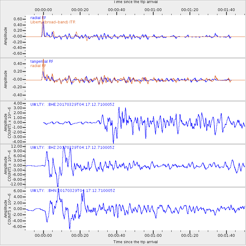
Signal To Noise
| Channel | StoN | STA | LTA |
| UW:LTY: :BHZ:20170329T04:17:12.710005Z | 27.539553 | 4.587248E-6 | 1.6656944E-7 |
| UW:LTY: :BHN:20170329T04:17:12.710005Z | 5.8232374 | 2.0657503E-6 | 3.547426E-7 |
| UW:LTY: :BHE:20170329T04:17:12.710005Z | 5.6106963 | 8.4935414E-7 | 1.5138123E-7 |
| Arrivals |
| Ps | 1.9 SECOND |
| PpPs | 4.9 SECOND |
| PsPs/PpSs | 6.8 SECOND |


