You are here: Home > Network List > X416 - Monitoring Active Faults for Tectonic Mapping Efforts in Washington State Stations List
> Station MA02 King County, WA, USA > Earthquake Result Viewer
MA02 King County, WA, USA - Earthquake Result Viewer
| Earthquake location: |
Near East Coast Of Kamchatka |
| Earthquake latitude/longitude: |
56.9/162.7 |
| Earthquake time(UTC): |
2017/03/29 (088) 04:09:24 GMT |
| Earthquake Depth: |
23 km |
| Earthquake Magnitude: |
6.6 Mww |
| Earthquake Catalog/Contributor: |
NEIC PDE/us |
|
| Network: |
X4 Monitoring Active Faults for Tectonic Mapping Efforts in Washington State |
| Station: |
MA02 King County, WA, USA |
| Lat/Lon: |
47.72 N/121.83 W |
| Elevation: |
-1.0 m |
|
| Distance: |
44.8 deg |
| Az: |
68.113 deg |
| Baz: |
311.093 deg |
| Ray Param: |
0.07167849 |
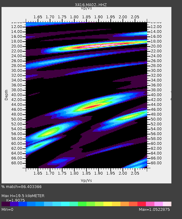
| Estimated Moho Depth: |
19.5 km |
| Estimated Crust Vp/Vs: |
1.91 |
| Assumed Crust Vp: |
6.597 km/s |
| Estimated Crust Vs: |
3.459 km/s |
| Estimated Crust Poisson's Ratio: |
0.31 |
|
| Radial Match: |
86.403366 % |
| Radial Bump: |
400 |
| Transverse Match: |
83.99839 % |
| Transverse Bump: |
400 |
| SOD ConfigId: |
11737051 |
| Insert Time: |
2019-04-27 00:31:57.468 +0000 |
| GWidth: |
2.5 |
| Max Bumps: |
400 |
| Tol: |
0.001 |
|

Signal To Noise
| Channel | StoN | STA | LTA |
| X4:MA02: :HHZ:20170329T04:17:05.560011Z | 12.863951 | 4.7390977E-6 | 3.6840143E-7 |
| X4:MA02: :HHN:20170329T04:17:05.560011Z | 2.359633 | 5.906656E-7 | 2.5032097E-7 |
| X4:MA02: :HHE:20170329T04:17:05.560011Z | 4.4278293 | 2.6874104E-6 | 6.069363E-7 |
| Arrivals |
| Ps | 2.9 SECOND |
| PpPs | 8.1 SECOND |
| PsPs/PpSs | 11 SECOND |


