You are here: Home > Network List > X416 - Monitoring Active Faults for Tectonic Mapping Efforts in Washington State Stations List
> Station LR12 Olympia, WA, USA > Earthquake Result Viewer
LR12 Olympia, WA, USA - Earthquake Result Viewer
| Earthquake location: |
Near East Coast Of Kamchatka |
| Earthquake latitude/longitude: |
56.9/162.7 |
| Earthquake time(UTC): |
2017/03/29 (088) 04:09:24 GMT |
| Earthquake Depth: |
23 km |
| Earthquake Magnitude: |
6.6 Mww |
| Earthquake Catalog/Contributor: |
NEIC PDE/us |
|
| Network: |
X4 Monitoring Active Faults for Tectonic Mapping Efforts in Washington State |
| Station: |
LR12 Olympia, WA, USA |
| Lat/Lon: |
46.98 N/123.07 W |
| Elevation: |
-1.0 m |
|
| Distance: |
44.6 deg |
| Az: |
69.702 deg |
| Baz: |
311.314 deg |
| Ray Param: |
0.07176555 |
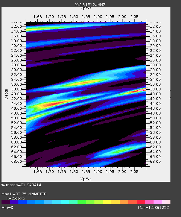
| Estimated Moho Depth: |
37.75 km |
| Estimated Crust Vp/Vs: |
2.10 |
| Assumed Crust Vp: |
6.566 km/s |
| Estimated Crust Vs: |
3.13 km/s |
| Estimated Crust Poisson's Ratio: |
0.35 |
|
| Radial Match: |
81.940414 % |
| Radial Bump: |
297 |
| Transverse Match: |
76.85844 % |
| Transverse Bump: |
379 |
| SOD ConfigId: |
11737051 |
| Insert Time: |
2019-04-27 00:31:57.901 +0000 |
| GWidth: |
2.5 |
| Max Bumps: |
400 |
| Tol: |
0.001 |
|

Signal To Noise
| Channel | StoN | STA | LTA |
| X4:LR12: :HHZ:20170329T04:17:04.439985Z | 7.698335 | 4.8791794E-6 | 6.337967E-7 |
| X4:LR12: :HHN:20170329T04:17:04.439985Z | 1.2153383 | 5.101074E-7 | 4.197246E-7 |
| X4:LR12: :HHE:20170329T04:17:04.439985Z | 6.3781886 | 1.9870326E-6 | 3.1153556E-7 |
| Arrivals |
| Ps | 6.7 SECOND |
| PpPs | 17 SECOND |
| PsPs/PpSs | 24 SECOND |


