You are here: Home > Network List > Y916 - Rapid Response for Fairview Aftershock in Oklahoma Stations List
> Station FW02 Waynoka, Oklahoma, USA > Earthquake Result Viewer
FW02 Waynoka, Oklahoma, USA - Earthquake Result Viewer
| Earthquake location: |
Near East Coast Of Kamchatka |
| Earthquake latitude/longitude: |
56.9/162.7 |
| Earthquake time(UTC): |
2017/03/29 (088) 04:09:24 GMT |
| Earthquake Depth: |
23 km |
| Earthquake Magnitude: |
6.6 Mww |
| Earthquake Catalog/Contributor: |
NEIC PDE/us |
|
| Network: |
Y9 Rapid Response for Fairview Aftershock in Oklahoma |
| Station: |
FW02 Waynoka, Oklahoma, USA |
| Lat/Lon: |
36.38 N/98.73 W |
| Elevation: |
434 m |
|
| Distance: |
64.7 deg |
| Az: |
62.019 deg |
| Baz: |
323.124 deg |
| Ray Param: |
0.058757793 |
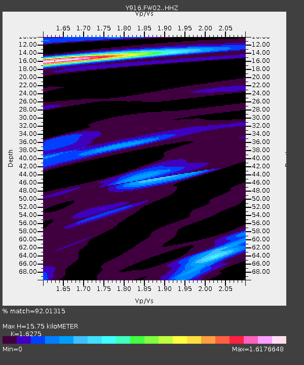
| Estimated Moho Depth: |
15.75 km |
| Estimated Crust Vp/Vs: |
1.63 |
| Assumed Crust Vp: |
6.426 km/s |
| Estimated Crust Vs: |
3.948 km/s |
| Estimated Crust Poisson's Ratio: |
0.20 |
|
| Radial Match: |
92.01315 % |
| Radial Bump: |
399 |
| Transverse Match: |
78.83074 % |
| Transverse Bump: |
400 |
| SOD ConfigId: |
11737051 |
| Insert Time: |
2019-04-27 00:32:14.973 +0000 |
| GWidth: |
2.5 |
| Max Bumps: |
400 |
| Tol: |
0.001 |
|

Signal To Noise
| Channel | StoN | STA | LTA |
| Y9:FW02: :HHZ:20170329T04:19:29.478987Z | 22.073769 | 4.3381197E-6 | 1.9652828E-7 |
| Y9:FW02: :HH1:20170329T04:19:29.478987Z | 11.6735325 | 1.7170472E-6 | 1.4708891E-7 |
| Y9:FW02: :HH2:20170329T04:19:29.478987Z | 2.2411695 | 5.2876834E-7 | 2.3593414E-7 |
| Arrivals |
| Ps | 1.6 SECOND |
| PpPs | 6.1 SECOND |
| PsPs/PpSs | 7.8 SECOND |


