You are here: Home > Network List > IU - Global Seismograph Network (GSN - IRIS/USGS) Stations List
> Station CTAO Charters Towers, Australia > Earthquake Result Viewer
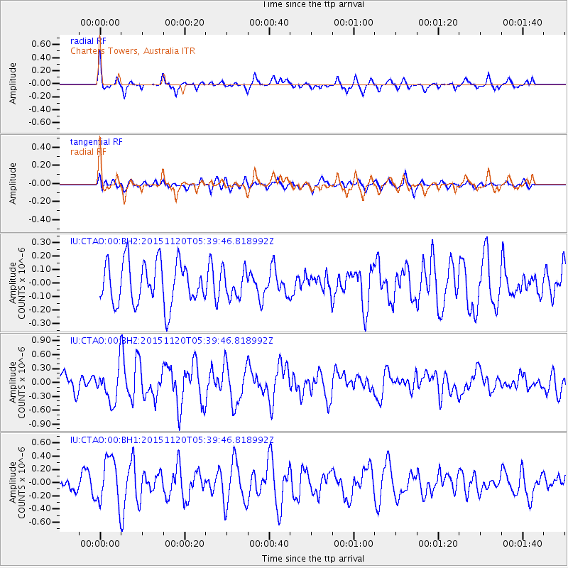
CTAO Charters Towers, Australia - Earthquake Result Viewer
*The percent match for this event was below the threshold and hence no stack was calculated.
| Earthquake location: |
Bonin Islands, Japan Region |
| Earthquake latitude/longitude: |
26.4/142.7 |
| Earthquake time(UTC): |
2015/11/20 (324) 05:31:52 GMT |
| Earthquake Depth: |
13 km |
| Earthquake Magnitude: |
5.5 MB |
| Earthquake Catalog/Contributor: |
NEIC PDE/NEIC COMCAT |
|
| Network: |
IU Global Seismograph Network (GSN - IRIS/USGS) |
| Station: |
CTAO Charters Towers, Australia |
| Lat/Lon: |
20.09 S/146.25 E |
| Elevation: |
357 m |
|
| Distance: |
46.3 deg |
| Az: |
175.386 deg |
| Baz: |
355.596 deg |
| Ray Param: |
$rayparam |
*The percent match for this event was below the threshold and hence was not used in the summary stack. |
|
| Radial Match: |
68.221146 % |
| Radial Bump: |
364 |
| Transverse Match: |
48.54145 % |
| Transverse Bump: |
400 |
| SOD ConfigId: |
1259291 |
| Insert Time: |
2015-12-04 06:26:30.493 +0000 |
| GWidth: |
2.5 |
| Max Bumps: |
400 |
| Tol: |
0.001 |
|
Signal To Noise
| Channel | StoN | STA | LTA |
| IU:CTAO:00:BHZ:20151120T05:39:46.818992Z | 1.9889218 | 3.7568174E-7 | 1.8888714E-7 |
| IU:CTAO:00:BH1:20151120T05:39:46.818992Z | 2.5619025 | 3.5604364E-7 | 1.3897626E-7 |
| IU:CTAO:00:BH2:20151120T05:39:46.818992Z | 0.6406877 | 9.96485E-8 | 1.5553366E-7 |
| Arrivals |
| Ps | |
| PpPs | |
| PsPs/PpSs | |


