You are here: Home > Network List > TA - USArray Transportable Network (new EarthScope stations) Stations List
> Station N15A Stansbury Island BLM, Grantsville, UT, USA > Earthquake Result Viewer
N15A Stansbury Island BLM, Grantsville, UT, USA - Earthquake Result Viewer

| Earthquake location: |
Taiwan Region |
| Earthquake latitude/longitude: |
24.3/122.2 |
| Earthquake time(UTC): |
2007/09/06 (249) 17:51:26 GMT |
| Earthquake Depth: |
53 km |
| Earthquake Magnitude: |
6.1 MB, 6.2 MW, 6.1 ME |
| Earthquake Catalog/Contributor: |
WHDF/NEIC |
|
| Network: |
TA USArray Transportable Network (new EarthScope stations) |
| Station: |
N15A Stansbury Island BLM, Grantsville, UT, USA |
| Lat/Lon: |
40.89 N/112.52 W |
| Elevation: |
1408 m |
|
| Distance: |
97.6 deg |
| Az: |
38.646 deg |
| Baz: |
311.291 deg |
| Ray Param: |
0.04013611 |
| Estimated Moho Depth: |
56.75 km |
| Estimated Crust Vp/Vs: |
1.72 |
| Assumed Crust Vp: |
6.276 km/s |
| Estimated Crust Vs: |
3.649 km/s |
| Estimated Crust Poisson's Ratio: |
0.24 |
|
| Radial Match: |
81.37883 % |
| Radial Bump: |
400 |
| Transverse Match: |
71.33512 % |
| Transverse Bump: |
370 |
| SOD ConfigId: |
2564 |
| Insert Time: |
2010-03-05 22:44:03.843 +0000 |
| GWidth: |
2.5 |
| Max Bumps: |
400 |
| Tol: |
0.001 |
|
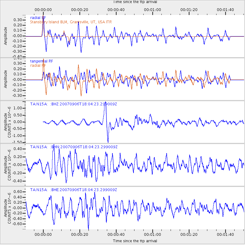
Signal To Noise
| Channel | StoN | STA | LTA |
| TA:N15A: :BHN:20070906T18:04:23.299009Z | 1.4353068 | 1.5935564E-7 | 1.1102549E-7 |
| TA:N15A: :BHE:20070906T18:04:23.299009Z | 1.731862 | 2.4018317E-7 | 1.3868494E-7 |
| TA:N15A: :BHZ:20070906T18:04:23.299009Z | 5.5607395 | 6.1007995E-7 | 1.0971201E-7 |
| Arrivals |
| Ps | 6.6 SECOND |
| PpPs | 24 SECOND |
| PsPs/PpSs | 31 SECOND |


