You are here: Home > Network List > TA - USArray Transportable Network (new EarthScope stations) Stations List
> Station N15A Stansbury Island BLM, Grantsville, UT, USA > Earthquake Result Viewer
N15A Stansbury Island BLM, Grantsville, UT, USA - Earthquake Result Viewer

| Earthquake location: |
Kuril Islands |
| Earthquake latitude/longitude: |
45.8/150.1 |
| Earthquake time(UTC): |
2007/09/03 (246) 16:14:53 GMT |
| Earthquake Depth: |
94 km |
| Earthquake Magnitude: |
6.3 MB, 6.2 MW, 6.2 ME |
| Earthquake Catalog/Contributor: |
WHDF/NEIC |
|
| Network: |
TA USArray Transportable Network (new EarthScope stations) |
| Station: |
N15A Stansbury Island BLM, Grantsville, UT, USA |
| Lat/Lon: |
40.89 N/112.52 W |
| Elevation: |
1408 m |
|
| Distance: |
66.6 deg |
| Az: |
55.026 deg |
| Baz: |
310.92 deg |
| Ray Param: |
0.057290915 |
| Estimated Moho Depth: |
27.5 km |
| Estimated Crust Vp/Vs: |
1.64 |
| Assumed Crust Vp: |
6.276 km/s |
| Estimated Crust Vs: |
3.815 km/s |
| Estimated Crust Poisson's Ratio: |
0.21 |
|
| Radial Match: |
94.16956 % |
| Radial Bump: |
361 |
| Transverse Match: |
88.62862 % |
| Transverse Bump: |
400 |
| SOD ConfigId: |
2564 |
| Insert Time: |
2010-03-05 22:44:06.316 +0000 |
| GWidth: |
2.5 |
| Max Bumps: |
400 |
| Tol: |
0.001 |
|
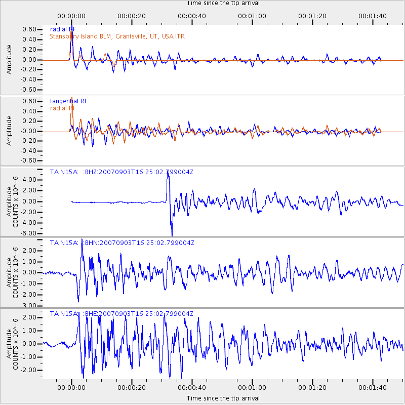
Signal To Noise
| Channel | StoN | STA | LTA |
| TA:N15A: :BHN:20070903T16:25:02.799004Z | 13.219376 | 1.1909466E-6 | 9.0090985E-8 |
| TA:N15A: :BHE:20070903T16:25:02.799004Z | 9.713444 | 1.1141177E-6 | 1.1469852E-7 |
| TA:N15A: :BHZ:20070903T16:25:02.799004Z | 48.429913 | 2.778701E-6 | 5.737572E-8 |
| Arrivals |
| Ps | 2.9 SECOND |
| PpPs | 11 SECOND |
| PsPs/PpSs | 14 SECOND |


