You are here: Home > Network List > TA - USArray Transportable Network (new EarthScope stations) Stations List
> Station A21K Barrow, AK, USA > Earthquake Result Viewer
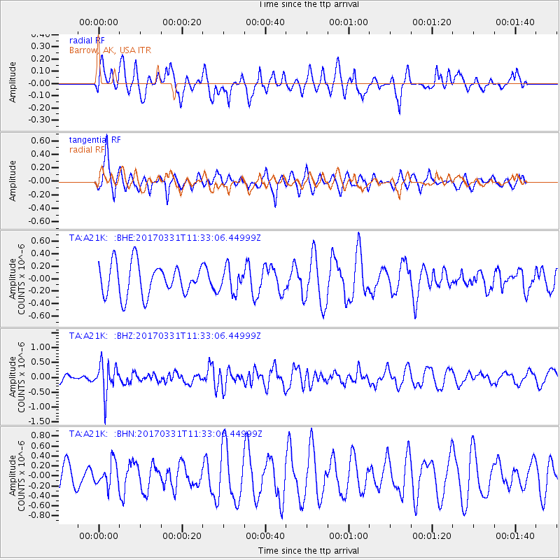
A21K Barrow, AK, USA - Earthquake Result Viewer
*The percent match for this event was below the threshold and hence no stack was calculated.
| Earthquake location: |
Minahassa Peninsula, Sulawesi |
| Earthquake latitude/longitude: |
0.3/120.6 |
| Earthquake time(UTC): |
2017/03/31 (090) 11:21:00 GMT |
| Earthquake Depth: |
93 km |
| Earthquake Magnitude: |
5.6 mb |
| Earthquake Catalog/Contributor: |
NEIC PDE/us |
|
| Network: |
TA USArray Transportable Network (new EarthScope stations) |
| Station: |
A21K Barrow, AK, USA |
| Lat/Lon: |
71.32 N/156.62 W |
| Elevation: |
577 m |
|
| Distance: |
87.4 deg |
| Az: |
18.66 deg |
| Baz: |
263.249 deg |
| Ray Param: |
$rayparam |
*The percent match for this event was below the threshold and hence was not used in the summary stack. |
|
| Radial Match: |
45.655914 % |
| Radial Bump: |
394 |
| Transverse Match: |
40.105145 % |
| Transverse Bump: |
370 |
| SOD ConfigId: |
11737051 |
| Insert Time: |
2019-04-27 00:47:18.541 +0000 |
| GWidth: |
2.5 |
| Max Bumps: |
400 |
| Tol: |
0.001 |
|
Signal To Noise
| Channel | StoN | STA | LTA |
| TA:A21K: :BHZ:20170331T11:33:06.44999Z | 4.050094 | 5.161719E-7 | 1.2744688E-7 |
| TA:A21K: :BHN:20170331T11:33:06.44999Z | 0.9307166 | 2.443534E-7 | 2.625433E-7 |
| TA:A21K: :BHE:20170331T11:33:06.44999Z | 0.7554647 | 1.9159367E-7 | 2.5361035E-7 |
| Arrivals |
| Ps | |
| PpPs | |
| PsPs/PpSs | |


