You are here: Home > Network List > CI - Caltech Regional Seismic Network Stations List
> Station EDW2 EDW2, Mojave, CA, USA > Earthquake Result Viewer
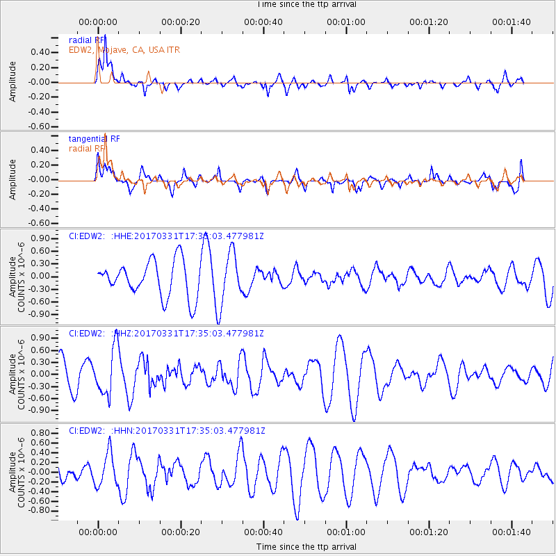
EDW2 EDW2, Mojave, CA, USA - Earthquake Result Viewer
*The percent match for this event was below the threshold and hence no stack was calculated.
| Earthquake location: |
Reykjanes Ridge |
| Earthquake latitude/longitude: |
52.7/-32.3 |
| Earthquake time(UTC): |
2017/03/31 (090) 17:25:23 GMT |
| Earthquake Depth: |
10 km |
| Earthquake Magnitude: |
5.5 Mww |
| Earthquake Catalog/Contributor: |
NEIC PDE/us |
|
| Network: |
CI Caltech Regional Seismic Network |
| Station: |
EDW2 EDW2, Mojave, CA, USA |
| Lat/Lon: |
34.88 N/117.99 W |
| Elevation: |
772 m |
|
| Distance: |
60.7 deg |
| Az: |
289.949 deg |
| Baz: |
44.126 deg |
| Ray Param: |
$rayparam |
*The percent match for this event was below the threshold and hence was not used in the summary stack. |
|
| Radial Match: |
68.81868 % |
| Radial Bump: |
400 |
| Transverse Match: |
40.391457 % |
| Transverse Bump: |
400 |
| SOD ConfigId: |
11737051 |
| Insert Time: |
2019-04-27 00:50:22.861 +0000 |
| GWidth: |
2.5 |
| Max Bumps: |
400 |
| Tol: |
0.001 |
|
Signal To Noise
| Channel | StoN | STA | LTA |
| CI:EDW2: :HHZ:20170331T17:35:03.477981Z | 2.4098933 | 6.0301534E-7 | 2.5022493E-7 |
| CI:EDW2: :HHN:20170331T17:35:03.477981Z | 1.8269401 | 3.4717473E-7 | 1.900307E-7 |
| CI:EDW2: :HHE:20170331T17:35:03.477981Z | 1.4637148 | 6.1251785E-7 | 4.1846803E-7 |
| Arrivals |
| Ps | |
| PpPs | |
| PsPs/PpSs | |


