You are here: Home > Network List > TJ - Tajikistan National Seismic Network Stations List
> Station SHAA Shaartuz, Tajikistan > Earthquake Result Viewer
SHAA Shaartuz, Tajikistan - Earthquake Result Viewer
| Earthquake location: |
Botswana |
| Earthquake latitude/longitude: |
-22.7/25.1 |
| Earthquake time(UTC): |
2017/04/03 (093) 17:40:18 GMT |
| Earthquake Depth: |
29 km |
| Earthquake Magnitude: |
6.5 Mww |
| Earthquake Catalog/Contributor: |
NEIC PDE/us |
|
| Network: |
TJ Tajikistan National Seismic Network |
| Station: |
SHAA Shaartuz, Tajikistan |
| Lat/Lon: |
37.56 N/68.12 E |
| Elevation: |
868 m |
|
| Distance: |
72.3 deg |
| Az: |
34.662 deg |
| Baz: |
221.384 deg |
| Ray Param: |
0.05373318 |
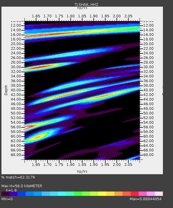
| Estimated Moho Depth: |
56.0 km |
| Estimated Crust Vp/Vs: |
1.60 |
| Assumed Crust Vp: |
6.213 km/s |
| Estimated Crust Vs: |
3.883 km/s |
| Estimated Crust Poisson's Ratio: |
0.18 |
|
| Radial Match: |
82.3179 % |
| Radial Bump: |
400 |
| Transverse Match: |
77.813835 % |
| Transverse Bump: |
400 |
| SOD ConfigId: |
11737051 |
| Insert Time: |
2019-04-27 01:03:15.097 +0000 |
| GWidth: |
2.5 |
| Max Bumps: |
400 |
| Tol: |
0.001 |
|

Signal To Noise
| Channel | StoN | STA | LTA |
| TJ:SHAA: :HHZ:20170403T17:51:10.159995Z | 49.673958 | 1.0800815E-5 | 2.1743416E-7 |
| TJ:SHAA: :HHN:20170403T17:51:10.159995Z | 14.726554 | 2.145053E-6 | 1.4565886E-7 |
| TJ:SHAA: :HHE:20170403T17:51:10.159995Z | 9.135642 | 2.1407905E-6 | 2.3433387E-7 |
| Arrivals |
| Ps | 5.6 SECOND |
| PpPs | 23 SECOND |
| PsPs/PpSs | 28 SECOND |


