You are here: Home > Network List > TA - USArray Transportable Network (new EarthScope stations) Stations List
> Station KMSC Kings Mountain, Blacksburg, SC, USA > Earthquake Result Viewer
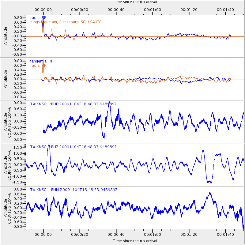
KMSC Kings Mountain, Blacksburg, SC, USA - Earthquake Result Viewer

| Earthquake location: |
Azores Islands Region |
| Earthquake latitude/longitude: |
36.2/-33.9 |
| Earthquake time(UTC): |
2009/11/04 (308) 18:41:44 GMT |
| Earthquake Depth: |
10 km |
| Earthquake Magnitude: |
5.7 MB, 5.6 MS, 5.9 MW, 5.8 MW |
| Earthquake Catalog/Contributor: |
WHDF/NEIC |
|
| Network: |
TA USArray Transportable Network (new EarthScope stations) |
| Station: |
KMSC Kings Mountain, Blacksburg, SC, USA |
| Lat/Lon: |
35.14 N/81.33 W |
| Elevation: |
240 m |
|
| Distance: |
38.3 deg |
| Az: |
282.899 deg |
| Baz: |
74.281 deg |
| Ray Param: |
0.07565466 |
| Estimated Moho Depth: |
15.75 km |
| Estimated Crust Vp/Vs: |
1.61 |
| Assumed Crust Vp: |
6.419 km/s |
| Estimated Crust Vs: |
4.0 km/s |
| Estimated Crust Poisson's Ratio: |
0.18 |
|
| Radial Match: |
80.24742 % |
| Radial Bump: |
400 |
| Transverse Match: |
46.183453 % |
| Transverse Bump: |
400 |
| SOD ConfigId: |
2622 |
| Insert Time: |
2010-03-05 22:46:06.997 +0000 |
| GWidth: |
2.5 |
| Max Bumps: |
400 |
| Tol: |
0.001 |
|
Signal To Noise
| Channel | StoN | STA | LTA |
| TA:KMSC: :BHZ:20091104T18:48:33.948989Z | 7.4797626 | 8.857025E-7 | 1.1841318E-7 |
| TA:KMSC: :BHN:20091104T18:48:33.948989Z | 1.2026662 | 2.6325623E-7 | 2.1889385E-7 |
| TA:KMSC: :BHE:20091104T18:48:33.948989Z | 1.8341782 | 3.8853528E-7 | 2.1183072E-7 |
| Arrivals |
| Ps | 1.6 SECOND |
| PpPs | 5.9 SECOND |
| PsPs/PpSs | 7.5 SECOND |


