You are here: Home > Network List > CI - Caltech Regional Seismic Network Stations List
> Station MPM Manuel Prospect Mine, California, USA > Earthquake Result Viewer
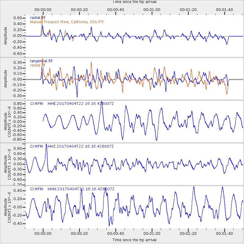
MPM Manuel Prospect Mine, California, USA - Earthquake Result Viewer
*The percent match for this event was below the threshold and hence no stack was calculated.
| Earthquake location: |
Andreanof Islands, Aleutian Is. |
| Earthquake latitude/longitude: |
51.3/-176.4 |
| Earthquake time(UTC): |
2017/04/04 (094) 22:08:40 GMT |
| Earthquake Depth: |
13 km |
| Earthquake Magnitude: |
5.5 Mww |
| Earthquake Catalog/Contributor: |
NEIC PDE/us |
|
| Network: |
CI Caltech Regional Seismic Network |
| Station: |
MPM Manuel Prospect Mine, California, USA |
| Lat/Lon: |
36.06 N/117.49 W |
| Elevation: |
185 m |
|
| Distance: |
44.1 deg |
| Az: |
86.456 deg |
| Baz: |
309.302 deg |
| Ray Param: |
$rayparam |
*The percent match for this event was below the threshold and hence was not used in the summary stack. |
|
| Radial Match: |
67.496864 % |
| Radial Bump: |
391 |
| Transverse Match: |
77.52829 % |
| Transverse Bump: |
400 |
| SOD ConfigId: |
11737051 |
| Insert Time: |
2019-04-27 01:09:57.209 +0000 |
| GWidth: |
2.5 |
| Max Bumps: |
400 |
| Tol: |
0.001 |
|
Signal To Noise
| Channel | StoN | STA | LTA |
| CI:MPM: :HHZ:20170404T22:16:16.428007Z | 1.5138363 | 4.9344146E-7 | 3.259543E-7 |
| CI:MPM: :HHN:20170404T22:16:16.428007Z | 0.8239311 | 1.309918E-7 | 1.5898392E-7 |
| CI:MPM: :HHE:20170404T22:16:16.428007Z | 2.1510832 | 4.5471293E-7 | 2.1138788E-7 |
| Arrivals |
| Ps | |
| PpPs | |
| PsPs/PpSs | |


