You are here: Home > Network List > GS - US Geological Survey Networks Stations List
> Station KAN11 Stewart Ranch, Harper County, KS, USA > Earthquake Result Viewer
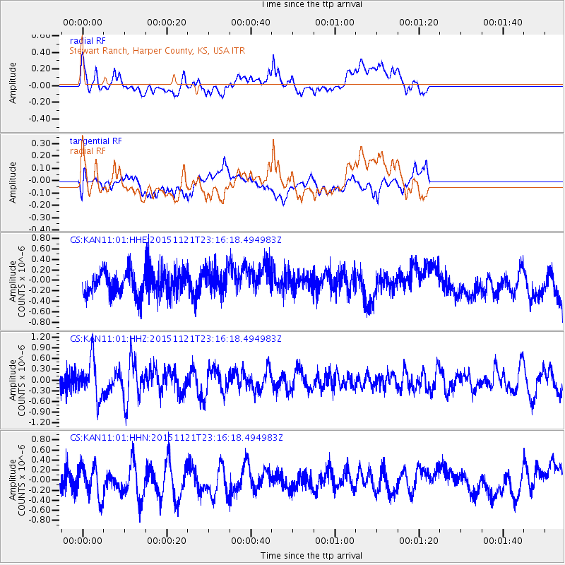
KAN11 Stewart Ranch, Harper County, KS, USA - Earthquake Result Viewer
*The percent match for this event was below the threshold and hence no stack was calculated.
| Earthquake location: |
Near Coast Of Central Chile |
| Earthquake latitude/longitude: |
-30.6/-71.8 |
| Earthquake time(UTC): |
2015/11/21 (325) 23:05:29 GMT |
| Earthquake Depth: |
24 km |
| Earthquake Magnitude: |
5.5 MB |
| Earthquake Catalog/Contributor: |
NEIC PDE/NEIC COMCAT |
|
| Network: |
GS US Geological Survey Networks |
| Station: |
KAN11 Stewart Ranch, Harper County, KS, USA |
| Lat/Lon: |
37.21 N/97.91 W |
| Elevation: |
410 m |
|
| Distance: |
71.7 deg |
| Az: |
338.279 deg |
| Baz: |
156.437 deg |
| Ray Param: |
$rayparam |
*The percent match for this event was below the threshold and hence was not used in the summary stack. |
|
| Radial Match: |
41.50131 % |
| Radial Bump: |
400 |
| Transverse Match: |
30.396858 % |
| Transverse Bump: |
400 |
| SOD ConfigId: |
1259291 |
| Insert Time: |
2015-12-05 23:20:51.877 +0000 |
| GWidth: |
2.5 |
| Max Bumps: |
400 |
| Tol: |
0.001 |
|
Signal To Noise
| Channel | StoN | STA | LTA |
| GS:KAN11:01:HHZ:20151121T23:16:18.494983Z | 2.3012903 | 5.4097353E-7 | 2.3507401E-7 |
| GS:KAN11:01:HHN:20151121T23:16:18.494983Z | 0.9990835 | 4.0045802E-7 | 4.0082537E-7 |
| GS:KAN11:01:HHE:20151121T23:16:18.494983Z | 0.9856854 | 2.46737E-7 | 2.5032023E-7 |
| Arrivals |
| Ps | |
| PpPs | |
| PsPs/PpSs | |


