You are here: Home > Network List > TA - USArray Transportable Network (new EarthScope stations) Stations List
> Station M11A Holland Ranch, North Fork, NV, USA > Earthquake Result Viewer
M11A Holland Ranch, North Fork, NV, USA - Earthquake Result Viewer
| Earthquake location: |
Loyalty Islands |
| Earthquake latitude/longitude: |
-20.1/168.9 |
| Earthquake time(UTC): |
2008/04/09 (100) 12:46:12 GMT |
| Earthquake Depth: |
33 km |
| Earthquake Magnitude: |
6.3 MB, 7.3 MS, 7.3 MW, 7.3 MW |
| Earthquake Catalog/Contributor: |
WHDF/NEIC |
|
| Network: |
TA USArray Transportable Network (new EarthScope stations) |
| Station: |
M11A Holland Ranch, North Fork, NV, USA |
| Lat/Lon: |
41.43 N/115.79 W |
| Elevation: |
1849 m |
|
| Distance: |
92.6 deg |
| Az: |
46.732 deg |
| Baz: |
245.541 deg |
| Ray Param: |
0.04141134 |
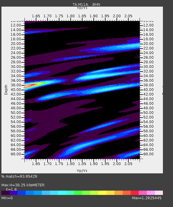
| Estimated Moho Depth: |
38.25 km |
| Estimated Crust Vp/Vs: |
1.60 |
| Assumed Crust Vp: |
6.276 km/s |
| Estimated Crust Vs: |
3.922 km/s |
| Estimated Crust Poisson's Ratio: |
0.18 |
|
| Radial Match: |
93.95429 % |
| Radial Bump: |
400 |
| Transverse Match: |
78.63312 % |
| Transverse Bump: |
400 |
| SOD ConfigId: |
2504 |
| Insert Time: |
2010-03-05 22:46:46.883 +0000 |
| GWidth: |
2.5 |
| Max Bumps: |
400 |
| Tol: |
0.001 |
|
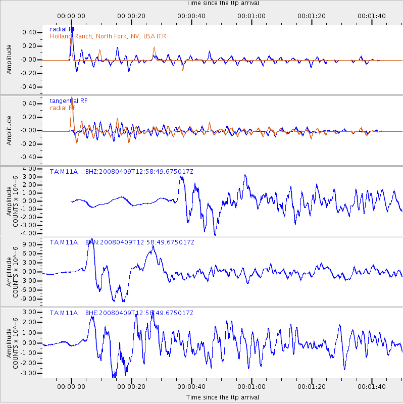
Signal To Noise
| Channel | StoN | STA | LTA |
| TA:M11A: :BHN:20080409T12:58:49.675017Z | 3.9541187 | 9.134615E-7 | 2.3101519E-7 |
| TA:M11A: :BHE:20080409T12:58:49.675017Z | 1.4115955 | 2.2772501E-7 | 1.6132455E-7 |
| TA:M11A: :BHZ:20080409T12:58:49.675017Z | 1.1063919 | 3.8168469E-7 | 3.449815E-7 |
| Arrivals |
| Ps | 3.7 SECOND |
| PpPs | 16 SECOND |
| PsPs/PpSs | 19 SECOND |


