You are here: Home > Network List > TA - USArray Transportable Network (new EarthScope stations) Stations List
> Station M11A Holland Ranch, North Fork, NV, USA > Earthquake Result Viewer
M11A Holland Ranch, North Fork, NV, USA - Earthquake Result Viewer
| Earthquake location: |
Near Coast Of Guatemala |
| Earthquake latitude/longitude: |
13.6/-90.6 |
| Earthquake time(UTC): |
2008/04/15 (106) 03:03:04 GMT |
| Earthquake Depth: |
33 km |
| Earthquake Magnitude: |
5.6 MB, 5.8 MS, 6.1 MW, 6.1 MW |
| Earthquake Catalog/Contributor: |
WHDF/NEIC |
|
| Network: |
TA USArray Transportable Network (new EarthScope stations) |
| Station: |
M11A Holland Ranch, North Fork, NV, USA |
| Lat/Lon: |
41.43 N/115.79 W |
| Elevation: |
1849 m |
|
| Distance: |
35.4 deg |
| Az: |
326.441 deg |
| Baz: |
134.364 deg |
| Ray Param: |
0.07719315 |
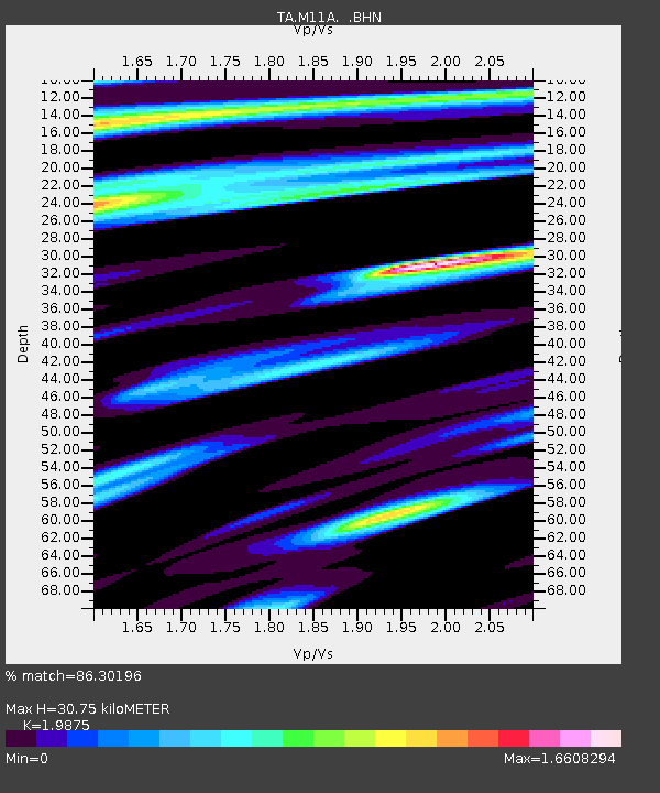
| Estimated Moho Depth: |
30.75 km |
| Estimated Crust Vp/Vs: |
1.99 |
| Assumed Crust Vp: |
6.276 km/s |
| Estimated Crust Vs: |
3.158 km/s |
| Estimated Crust Poisson's Ratio: |
0.33 |
|
| Radial Match: |
86.30196 % |
| Radial Bump: |
400 |
| Transverse Match: |
61.503857 % |
| Transverse Bump: |
400 |
| SOD ConfigId: |
2504 |
| Insert Time: |
2010-03-05 22:46:47.737 +0000 |
| GWidth: |
2.5 |
| Max Bumps: |
400 |
| Tol: |
0.001 |
|
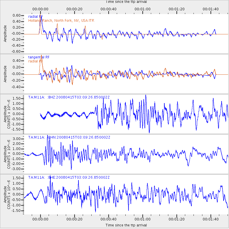
Signal To Noise
| Channel | StoN | STA | LTA |
| TA:M11A: :BHN:20080415T03:09:26.850002Z | 7.828769 | 1.3933194E-6 | 1.7797426E-7 |
| TA:M11A: :BHE:20080415T03:09:26.850002Z | 2.5695596 | 4.2326442E-7 | 1.6472256E-7 |
| TA:M11A: :BHZ:20080415T03:09:26.850002Z | 3.5666604 | 5.4058904E-7 | 1.5156729E-7 |
| Arrivals |
| Ps | 5.2 SECOND |
| PpPs | 14 SECOND |
| PsPs/PpSs | 19 SECOND |


