You are here: Home > Network List > TA - USArray Transportable Network (new EarthScope stations) Stations List
> Station M11A Holland Ranch, North Fork, NV, USA > Earthquake Result Viewer
M11A Holland Ranch, North Fork, NV, USA - Earthquake Result Viewer

| Earthquake location: |
Sea Of Okhotsk |
| Earthquake latitude/longitude: |
53.9/152.9 |
| Earthquake time(UTC): |
2008/07/05 (187) 02:12:04 GMT |
| Earthquake Depth: |
633 km |
| Earthquake Magnitude: |
6.8 MB, 7.7 MW, 7.7 MW |
| Earthquake Catalog/Contributor: |
WHDF/NEIC |
|
| Network: |
TA USArray Transportable Network (new EarthScope stations) |
| Station: |
M11A Holland Ranch, North Fork, NV, USA |
| Lat/Lon: |
41.43 N/115.79 W |
| Elevation: |
1849 m |
|
| Distance: |
58.6 deg |
| Az: |
61.73 deg |
| Baz: |
316.099 deg |
| Ray Param: |
0.060081024 |
| Estimated Moho Depth: |
17.0 km |
| Estimated Crust Vp/Vs: |
2.10 |
| Assumed Crust Vp: |
6.276 km/s |
| Estimated Crust Vs: |
2.992 km/s |
| Estimated Crust Poisson's Ratio: |
0.35 |
|
| Radial Match: |
95.134895 % |
| Radial Bump: |
400 |
| Transverse Match: |
76.42161 % |
| Transverse Bump: |
400 |
| SOD ConfigId: |
2504 |
| Insert Time: |
2010-03-05 22:46:58.170 +0000 |
| GWidth: |
2.5 |
| Max Bumps: |
400 |
| Tol: |
0.001 |
|
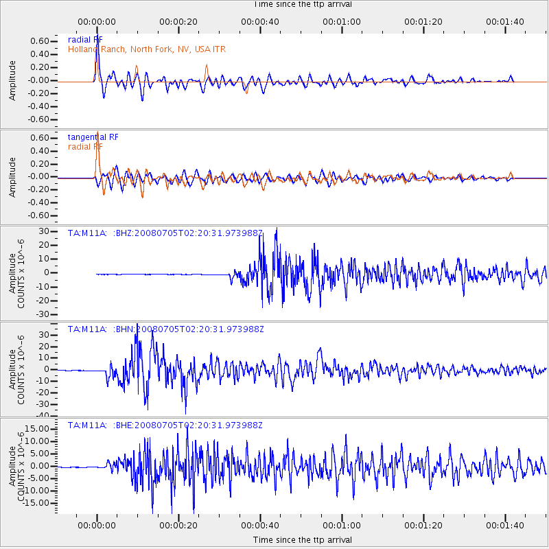
Signal To Noise
| Channel | StoN | STA | LTA |
| TA:M11A: :BHN:20080705T02:20:31.973988Z | 54.250263 | 4.343138E-6 | 8.0057454E-8 |
| TA:M11A: :BHE:20080705T02:20:31.973988Z | 13.882621 | 1.1869267E-6 | 8.5497305E-8 |
| TA:M11A: :BHZ:20080705T02:20:31.973988Z | 35.729748 | 2.0024988E-6 | 5.6045707E-8 |
| Arrivals |
| Ps | 3.1 SECOND |
| PpPs | 8.1 SECOND |
| PsPs/PpSs | 11 SECOND |


