You are here: Home > Network List > TA - USArray Transportable Network (new EarthScope stations) Stations List
> Station M11A Holland Ranch, North Fork, NV, USA > Earthquake Result Viewer
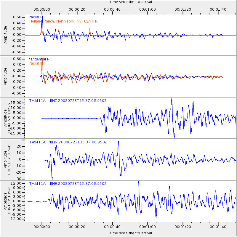
M11A Holland Ranch, North Fork, NV, USA - Earthquake Result Viewer
| Earthquake location: |
Eastern Honshu, Japan |
| Earthquake latitude/longitude: |
39.8/141.5 |
| Earthquake time(UTC): |
2008/07/23 (205) 15:26:19 GMT |
| Earthquake Depth: |
108 km |
| Earthquake Magnitude: |
6.6 MB, 6.8 MW, 6.8 MW |
| Earthquake Catalog/Contributor: |
WHDF/NEIC |
|
| Network: |
TA USArray Transportable Network (new EarthScope stations) |
| Station: |
M11A Holland Ranch, North Fork, NV, USA |
| Lat/Lon: |
41.43 N/115.79 W |
| Elevation: |
1849 m |
|
| Distance: |
73.0 deg |
| Az: |
50.083 deg |
| Baz: |
308.209 deg |
| Ray Param: |
0.053037338 |
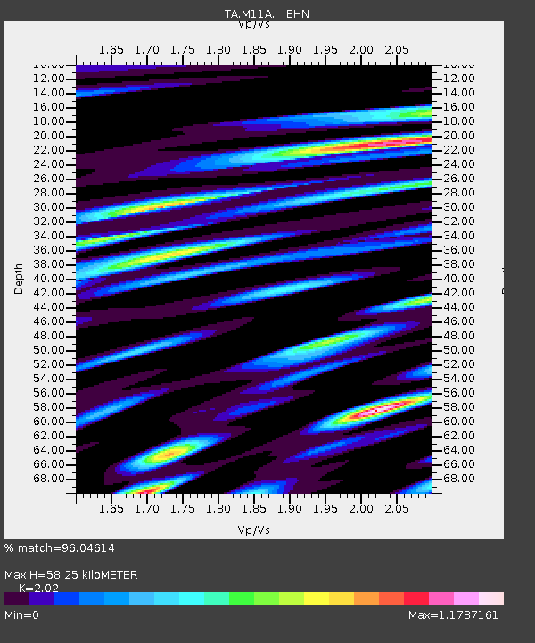
| Estimated Moho Depth: |
58.25 km |
| Estimated Crust Vp/Vs: |
2.02 |
| Assumed Crust Vp: |
6.276 km/s |
| Estimated Crust Vs: |
3.107 km/s |
| Estimated Crust Poisson's Ratio: |
0.34 |
|
| Radial Match: |
96.04614 % |
| Radial Bump: |
400 |
| Transverse Match: |
92.118454 % |
| Transverse Bump: |
400 |
| SOD ConfigId: |
2504 |
| Insert Time: |
2010-03-05 22:47:07.175 +0000 |
| GWidth: |
2.5 |
| Max Bumps: |
400 |
| Tol: |
0.001 |
|
Signal To Noise
| Channel | StoN | STA | LTA |
| TA:M11A: :BHN:20080723T15:37:06.950Z | 38.87041 | 4.4152957E-6 | 1.1359015E-7 |
| TA:M11A: :BHE:20080723T15:37:06.950Z | 9.457506 | 6.6817915E-7 | 7.065067E-8 |
| TA:M11A: :BHZ:20080723T15:37:06.950Z | 16.667196 | 1.9632985E-6 | 1.1779417E-7 |
| Arrivals |
| Ps | 9.7 SECOND |
| PpPs | 27 SECOND |
| PsPs/PpSs | 37 SECOND |


