You are here: Home > Network List > TA - USArray Transportable Network (new EarthScope stations) Stations List
> Station M11A Holland Ranch, North Fork, NV, USA > Earthquake Result Viewer
M11A Holland Ranch, North Fork, NV, USA - Earthquake Result Viewer

| Earthquake location: |
Peru-Ecuador Border Region |
| Earthquake latitude/longitude: |
-2.3/-77.8 |
| Earthquake time(UTC): |
2007/11/16 (320) 03:13:00 GMT |
| Earthquake Depth: |
123 km |
| Earthquake Magnitude: |
6.3 MB, 6.8 MW, 6.7 MW |
| Earthquake Catalog/Contributor: |
WHDF/NEIC |
|
| Network: |
TA USArray Transportable Network (new EarthScope stations) |
| Station: |
M11A Holland Ranch, North Fork, NV, USA |
| Lat/Lon: |
41.43 N/115.79 W |
| Elevation: |
1849 m |
|
| Distance: |
55.5 deg |
| Az: |
325.876 deg |
| Baz: |
131.804 deg |
| Ray Param: |
0.06435047 |
| Estimated Moho Depth: |
30.25 km |
| Estimated Crust Vp/Vs: |
2.08 |
| Assumed Crust Vp: |
6.276 km/s |
| Estimated Crust Vs: |
3.024 km/s |
| Estimated Crust Poisson's Ratio: |
0.35 |
|
| Radial Match: |
85.545395 % |
| Radial Bump: |
400 |
| Transverse Match: |
77.70394 % |
| Transverse Bump: |
400 |
| SOD ConfigId: |
2564 |
| Insert Time: |
2010-03-05 22:47:22.507 +0000 |
| GWidth: |
2.5 |
| Max Bumps: |
400 |
| Tol: |
0.001 |
|
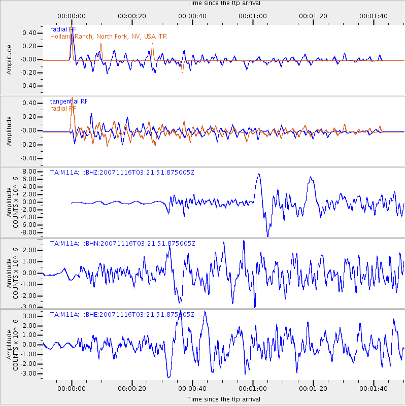
Signal To Noise
| Channel | StoN | STA | LTA |
| TA:M11A: :BHN:20071116T03:21:51.875005Z | 3.4153252 | 3.744355E-7 | 1.0963392E-7 |
| TA:M11A: :BHE:20071116T03:21:51.875005Z | 0.8745156 | 3.209797E-7 | 3.6703716E-7 |
| TA:M11A: :BHZ:20071116T03:21:51.875005Z | 4.765706 | 1.2023344E-6 | 2.5228883E-7 |
| Arrivals |
| Ps | 5.4 SECOND |
| PpPs | 14 SECOND |
| PsPs/PpSs | 20 SECOND |


