You are here: Home > Network List > TA - USArray Transportable Network (new EarthScope stations) Stations List
> Station M11A Holland Ranch, North Fork, NV, USA > Earthquake Result Viewer
M11A Holland Ranch, North Fork, NV, USA - Earthquake Result Viewer
| Earthquake location: |
South Of Mariana Islands |
| Earthquake latitude/longitude: |
10.5/145.7 |
| Earthquake time(UTC): |
2007/09/30 (273) 02:08:30 GMT |
| Earthquake Depth: |
14 km |
| Earthquake Magnitude: |
6.4 MB, 7.1 MS, 6.9 MW, 6.9 MW |
| Earthquake Catalog/Contributor: |
WHDF/NEIC |
|
| Network: |
TA USArray Transportable Network (new EarthScope stations) |
| Station: |
M11A Holland Ranch, North Fork, NV, USA |
| Lat/Lon: |
41.43 N/115.79 W |
| Elevation: |
1849 m |
|
| Distance: |
89.4 deg |
| Az: |
48.051 deg |
| Baz: |
283.374 deg |
| Ray Param: |
0.04183606 |
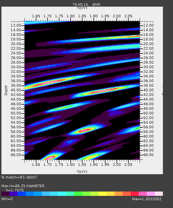
| Estimated Moho Depth: |
69.25 km |
| Estimated Crust Vp/Vs: |
1.71 |
| Assumed Crust Vp: |
6.276 km/s |
| Estimated Crust Vs: |
3.675 km/s |
| Estimated Crust Poisson's Ratio: |
0.24 |
|
| Radial Match: |
93.36007 % |
| Radial Bump: |
400 |
| Transverse Match: |
86.00378 % |
| Transverse Bump: |
400 |
| SOD ConfigId: |
2564 |
| Insert Time: |
2010-03-05 22:47:30.250 +0000 |
| GWidth: |
2.5 |
| Max Bumps: |
400 |
| Tol: |
0.001 |
|
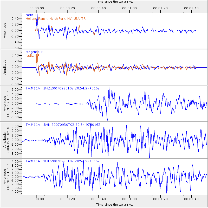
Signal To Noise
| Channel | StoN | STA | LTA |
| TA:M11A: :BHN:20070930T02:20:54.974016Z | 0.5290887 | 6.315882E-8 | 1.1937284E-7 |
| TA:M11A: :BHE:20070930T02:20:54.974016Z | 2.3072822 | 3.144586E-7 | 1.362896E-7 |
| TA:M11A: :BHZ:20070930T02:20:54.974016Z | 4.3773956 | 5.665639E-7 | 1.2942945E-7 |
| Arrivals |
| Ps | 8.0 SECOND |
| PpPs | 29 SECOND |
| PsPs/PpSs | 37 SECOND |


