You are here: Home > Network List > TA - USArray Transportable Network (new EarthScope stations) Stations List
> Station MSTX Muleshoe, TX, USA > Earthquake Result Viewer
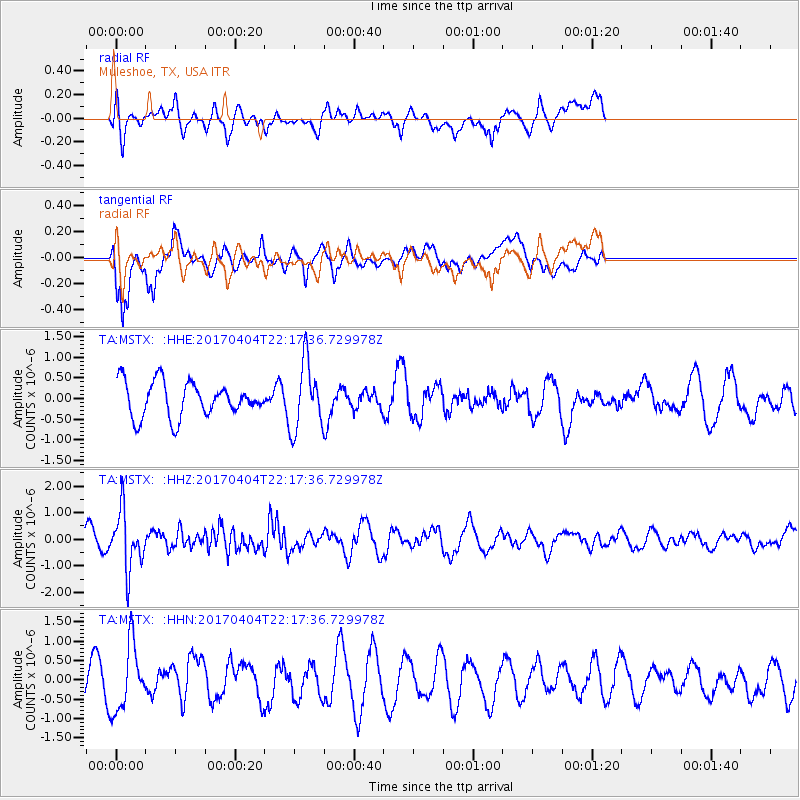
MSTX Muleshoe, TX, USA - Earthquake Result Viewer
*The percent match for this event was below the threshold and hence no stack was calculated.
| Earthquake location: |
Andreanof Islands, Aleutian Is. |
| Earthquake latitude/longitude: |
51.3/-176.4 |
| Earthquake time(UTC): |
2017/04/04 (094) 22:08:40 GMT |
| Earthquake Depth: |
13 km |
| Earthquake Magnitude: |
5.5 Mww |
| Earthquake Catalog/Contributor: |
NEIC PDE/us |
|
| Network: |
TA USArray Transportable Network (new EarthScope stations) |
| Station: |
MSTX Muleshoe, TX, USA |
| Lat/Lon: |
33.97 N/102.77 W |
| Elevation: |
1167 m |
|
| Distance: |
54.6 deg |
| Az: |
78.134 deg |
| Baz: |
312.288 deg |
| Ray Param: |
$rayparam |
*The percent match for this event was below the threshold and hence was not used in the summary stack. |
|
| Radial Match: |
45.233925 % |
| Radial Bump: |
400 |
| Transverse Match: |
66.25219 % |
| Transverse Bump: |
400 |
| SOD ConfigId: |
11737051 |
| Insert Time: |
2019-04-27 01:17:01.405 +0000 |
| GWidth: |
2.5 |
| Max Bumps: |
400 |
| Tol: |
0.001 |
|
Signal To Noise
| Channel | StoN | STA | LTA |
| TA:MSTX: :HHZ:20170404T22:17:36.729978Z | 3.0554252 | 1.0819472E-6 | 3.5410693E-7 |
| TA:MSTX: :HHN:20170404T22:17:36.729978Z | 2.0216963 | 8.4192305E-7 | 4.1644387E-7 |
| TA:MSTX: :HHE:20170404T22:17:36.729978Z | 1.9906768 | 8.261663E-7 | 4.150178E-7 |
| Arrivals |
| Ps | |
| PpPs | |
| PsPs/PpSs | |


