You are here: Home > Network List > TA - USArray Transportable Network (new EarthScope stations) Stations List
> Station M11A Holland Ranch, North Fork, NV, USA > Earthquake Result Viewer
M11A Holland Ranch, North Fork, NV, USA - Earthquake Result Viewer
| Earthquake location: |
Central East Pacific Rise |
| Earthquake latitude/longitude: |
-4.8/-105.4 |
| Earthquake time(UTC): |
2007/08/04 (216) 14:24:51 GMT |
| Earthquake Depth: |
10 km |
| Earthquake Magnitude: |
5.7 MS, 5.4 MB, 6.0 MW, 5.9 MW |
| Earthquake Catalog/Contributor: |
WHDF/NEIC |
|
| Network: |
TA USArray Transportable Network (new EarthScope stations) |
| Station: |
M11A Holland Ranch, North Fork, NV, USA |
| Lat/Lon: |
41.43 N/115.79 W |
| Elevation: |
1849 m |
|
| Distance: |
47.0 deg |
| Az: |
349.315 deg |
| Baz: |
165.775 deg |
| Ray Param: |
0.070298195 |
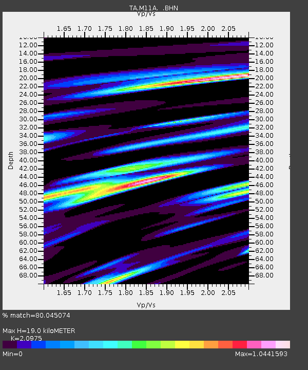
| Estimated Moho Depth: |
19.0 km |
| Estimated Crust Vp/Vs: |
2.10 |
| Assumed Crust Vp: |
6.276 km/s |
| Estimated Crust Vs: |
2.992 km/s |
| Estimated Crust Poisson's Ratio: |
0.35 |
|
| Radial Match: |
80.045074 % |
| Radial Bump: |
400 |
| Transverse Match: |
83.34149 % |
| Transverse Bump: |
400 |
| SOD ConfigId: |
2564 |
| Insert Time: |
2010-03-05 22:47:48.112 +0000 |
| GWidth: |
2.5 |
| Max Bumps: |
400 |
| Tol: |
0.001 |
|
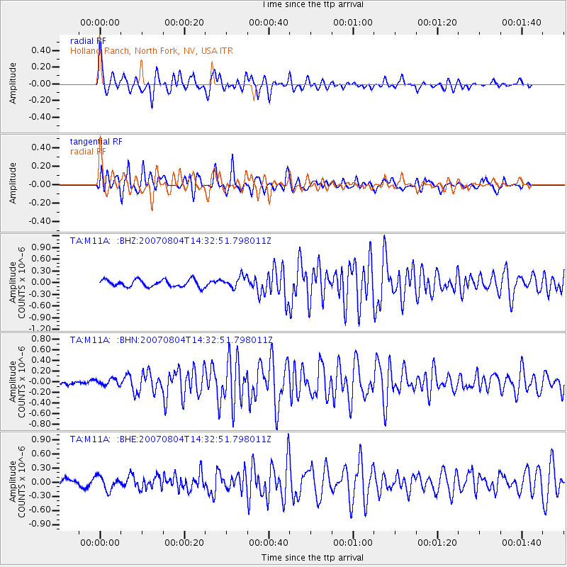
Signal To Noise
| Channel | StoN | STA | LTA |
| TA:M11A: :BHN:20070804T14:32:51.798011Z | 0.8967045 | 5.8854862E-8 | 6.563462E-8 |
| TA:M11A: :BHE:20070804T14:32:51.798011Z | 2.184521 | 1.4399274E-7 | 6.591502E-8 |
| TA:M11A: :BHZ:20070804T14:32:51.798011Z | 1.6695604 | 1.5266139E-7 | 9.1438075E-8 |
| Arrivals |
| Ps | 3.5 SECOND |
| PpPs | 8.9 SECOND |
| PsPs/PpSs | 12 SECOND |


