You are here: Home > Network List > TA - USArray Transportable Network (new EarthScope stations) Stations List
> Station M11A Holland Ranch, North Fork, NV, USA > Earthquake Result Viewer
M11A Holland Ranch, North Fork, NV, USA - Earthquake Result Viewer

| Earthquake location: |
Near West Coast Of Honshu, Japan |
| Earthquake latitude/longitude: |
37.5/138.4 |
| Earthquake time(UTC): |
2007/07/16 (197) 01:13:22 GMT |
| Earthquake Depth: |
12 km |
| Earthquake Magnitude: |
6.5 MB, 6.4 MS, 6.6 MW, 6.5 MW |
| Earthquake Catalog/Contributor: |
WHDF/NEIC |
|
| Network: |
TA USArray Transportable Network (new EarthScope stations) |
| Station: |
M11A Holland Ranch, North Fork, NV, USA |
| Lat/Lon: |
41.43 N/115.79 W |
| Elevation: |
1849 m |
|
| Distance: |
76.3 deg |
| Az: |
48.159 deg |
| Baz: |
308.038 deg |
| Ray Param: |
0.05111109 |
| Estimated Moho Depth: |
58.0 km |
| Estimated Crust Vp/Vs: |
2.03 |
| Assumed Crust Vp: |
6.276 km/s |
| Estimated Crust Vs: |
3.095 km/s |
| Estimated Crust Poisson's Ratio: |
0.34 |
|
| Radial Match: |
95.31588 % |
| Radial Bump: |
400 |
| Transverse Match: |
94.224014 % |
| Transverse Bump: |
400 |
| SOD ConfigId: |
2564 |
| Insert Time: |
2010-03-05 22:48:05.682 +0000 |
| GWidth: |
2.5 |
| Max Bumps: |
400 |
| Tol: |
0.001 |
|
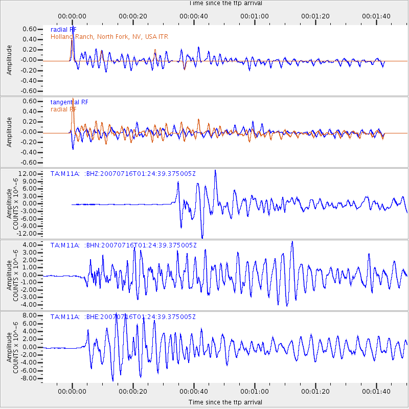
Signal To Noise
| Channel | StoN | STA | LTA |
| TA:M11A: :BHN:20070716T01:24:39.375005Z | 6.199597 | 3.1552943E-7 | 5.0895153E-8 |
| TA:M11A: :BHE:20070716T01:24:39.375005Z | 10.508757 | 4.697088E-7 | 4.4696893E-8 |
| TA:M11A: :BHZ:20070716T01:24:39.375005Z | 42.783825 | 2.197708E-6 | 5.1367735E-8 |
| Arrivals |
| Ps | 9.7 SECOND |
| PpPs | 27 SECOND |
| PsPs/PpSs | 37 SECOND |


