You are here: Home > Network List > TA - USArray Transportable Network (new EarthScope stations) Stations List
> Station M11A Holland Ranch, North Fork, NV, USA > Earthquake Result Viewer
M11A Holland Ranch, North Fork, NV, USA - Earthquake Result Viewer

| Earthquake location: |
Mariana Islands |
| Earthquake latitude/longitude: |
21.0/144.7 |
| Earthquake time(UTC): |
2007/01/30 (030) 21:37:45 GMT |
| Earthquake Depth: |
30 km |
| Earthquake Magnitude: |
6.3 MB, 6.5 MS, 6.6 MW, 6.5 MW |
| Earthquake Catalog/Contributor: |
WHDF/NEIC |
|
| Network: |
TA USArray Transportable Network (new EarthScope stations) |
| Station: |
M11A Holland Ranch, North Fork, NV, USA |
| Lat/Lon: |
41.43 N/115.79 W |
| Elevation: |
1849 m |
|
| Distance: |
83.2 deg |
| Az: |
48.321 deg |
| Baz: |
291.848 deg |
| Ray Param: |
0.04632657 |
| Estimated Moho Depth: |
69.75 km |
| Estimated Crust Vp/Vs: |
1.69 |
| Assumed Crust Vp: |
6.276 km/s |
| Estimated Crust Vs: |
3.708 km/s |
| Estimated Crust Poisson's Ratio: |
0.23 |
|
| Radial Match: |
84.39236 % |
| Radial Bump: |
400 |
| Transverse Match: |
79.8573 % |
| Transverse Bump: |
400 |
| SOD ConfigId: |
2564 |
| Insert Time: |
2010-03-05 22:48:27.906 +0000 |
| GWidth: |
2.5 |
| Max Bumps: |
400 |
| Tol: |
0.001 |
|
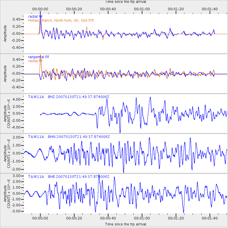
Signal To Noise
| Channel | StoN | STA | LTA |
| TA:M11A: :BHN:20070130T21:49:37.874006Z | 2.0741336 | 4.94761E-7 | 2.3853866E-7 |
| TA:M11A: :BHE:20070130T21:49:37.874006Z | 2.0399768 | 6.10862E-7 | 2.9944553E-7 |
| TA:M11A: :BHZ:20070130T21:49:37.874006Z | 5.790527 | 1.3122558E-6 | 2.2662115E-7 |
| Arrivals |
| Ps | 7.9 SECOND |
| PpPs | 29 SECOND |
| PsPs/PpSs | 37 SECOND |


