You are here: Home > Network List > TA - USArray Transportable Network (new EarthScope stations) Stations List
> Station M11A Holland Ranch, North Fork, NV, USA > Earthquake Result Viewer
M11A Holland Ranch, North Fork, NV, USA - Earthquake Result Viewer
| Earthquake location: |
Andreanof Islands, Aleutian Is. |
| Earthquake latitude/longitude: |
51.2/-179.3 |
| Earthquake time(UTC): |
2006/07/08 (189) 20:40:00 GMT |
| Earthquake Depth: |
22 km |
| Earthquake Magnitude: |
6.2 MB, 6.4 MS, 6.6 MW, 6.6 MW |
| Earthquake Catalog/Contributor: |
WHDF/NEIC |
|
| Network: |
TA USArray Transportable Network (new EarthScope stations) |
| Station: |
M11A Holland Ranch, North Fork, NV, USA |
| Lat/Lon: |
41.43 N/115.79 W |
| Elevation: |
1849 m |
|
| Distance: |
43.7 deg |
| Az: |
77.115 deg |
| Baz: |
305.375 deg |
| Ray Param: |
0.07237074 |
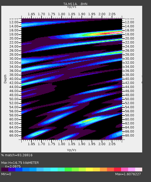
| Estimated Moho Depth: |
16.75 km |
| Estimated Crust Vp/Vs: |
2.10 |
| Assumed Crust Vp: |
6.276 km/s |
| Estimated Crust Vs: |
2.992 km/s |
| Estimated Crust Poisson's Ratio: |
0.35 |
|
| Radial Match: |
93.26916 % |
| Radial Bump: |
400 |
| Transverse Match: |
83.40788 % |
| Transverse Bump: |
400 |
| SOD ConfigId: |
5423 |
| Insert Time: |
2010-03-05 22:48:45.494 +0000 |
| GWidth: |
2.5 |
| Max Bumps: |
400 |
| Tol: |
0.001 |
|

Signal To Noise
| Channel | StoN | STA | LTA |
| TA:M11A: :BHN:20060708T20:47:33.200001Z | 2.5192173 | 2.0940782E-7 | 8.312416E-8 |
| TA:M11A: :BHE:20060708T20:47:33.200001Z | 6.5316567 | 5.0162305E-7 | 7.679875E-8 |
| TA:M11A: :BHZ:20060708T20:47:33.200001Z | 11.782676 | 7.895801E-7 | 6.701195E-8 |
| Arrivals |
| Ps | 3.1 SECOND |
| PpPs | 7.8 SECOND |
| PsPs/PpSs | 11 SECOND |


