You are here: Home > Network List > US - United States National Seismic Network Stations List
> Station AMTX Amarillo, Texas, USA > Earthquake Result Viewer
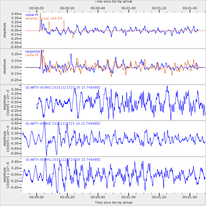
AMTX Amarillo, Texas, USA - Earthquake Result Viewer
*The percent match for this event was below the threshold and hence no stack was calculated.
| Earthquake location: |
Near Coast Of Central Chile |
| Earthquake latitude/longitude: |
-30.6/-71.8 |
| Earthquake time(UTC): |
2015/11/21 (325) 23:05:29 GMT |
| Earthquake Depth: |
24 km |
| Earthquake Magnitude: |
5.5 MB |
| Earthquake Catalog/Contributor: |
NEIC PDE/NEIC COMCAT |
|
| Network: |
US United States National Seismic Network |
| Station: |
AMTX Amarillo, Texas, USA |
| Lat/Lon: |
34.53 N/101.41 W |
| Elevation: |
1010 m |
|
| Distance: |
70.5 deg |
| Az: |
334.363 deg |
| Baz: |
153.13 deg |
| Ray Param: |
$rayparam |
*The percent match for this event was below the threshold and hence was not used in the summary stack. |
|
| Radial Match: |
61.934566 % |
| Radial Bump: |
400 |
| Transverse Match: |
67.114204 % |
| Transverse Bump: |
400 |
| SOD ConfigId: |
1259291 |
| Insert Time: |
2015-12-05 23:25:32.780 +0000 |
| GWidth: |
2.5 |
| Max Bumps: |
400 |
| Tol: |
0.001 |
|
Signal To Noise
| Channel | StoN | STA | LTA |
| US:AMTX:00:BHZ:20151121T23:16:13.749988Z | 1.7712779 | 3.2350766E-7 | 1.8264083E-7 |
| US:AMTX:00:BH1:20151121T23:16:13.749988Z | 1.3748478 | 1.5395061E-7 | 1.11976476E-7 |
| US:AMTX:00:BH2:20151121T23:16:13.749988Z | 1.6532906 | 1.7505846E-7 | 1.0588487E-7 |
| Arrivals |
| Ps | |
| PpPs | |
| PsPs/PpSs | |


