You are here: Home > Network List > TA - USArray Transportable Network (new EarthScope stations) Stations List
> Station M11A Holland Ranch, North Fork, NV, USA > Earthquake Result Viewer
M11A Holland Ranch, North Fork, NV, USA - Earthquake Result Viewer
| Earthquake location: |
Kuril Islands |
| Earthquake latitude/longitude: |
49.8/156.4 |
| Earthquake time(UTC): |
2006/08/20 (232) 03:01:02 GMT |
| Earthquake Depth: |
26 km |
| Earthquake Magnitude: |
5.8 MB, 5.7 MS, 6.0 MW, 5.9 MW |
| Earthquake Catalog/Contributor: |
WHDF/NEIC |
|
| Network: |
TA USArray Transportable Network (new EarthScope stations) |
| Station: |
M11A Holland Ranch, North Fork, NV, USA |
| Lat/Lon: |
41.43 N/115.79 W |
| Elevation: |
1849 m |
|
| Distance: |
58.6 deg |
| Az: |
61.681 deg |
| Baz: |
310.69 deg |
| Ray Param: |
0.062700264 |
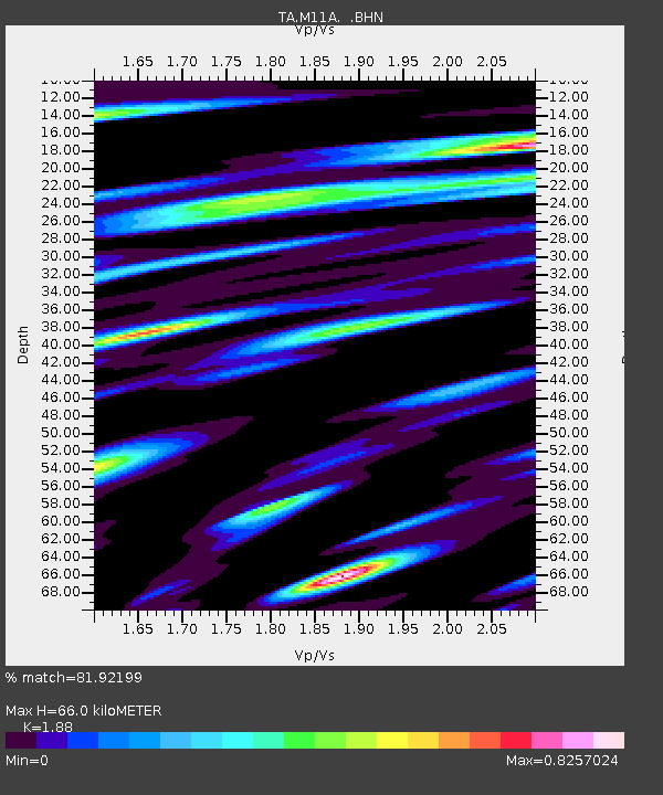
| Estimated Moho Depth: |
66.0 km |
| Estimated Crust Vp/Vs: |
1.88 |
| Assumed Crust Vp: |
6.276 km/s |
| Estimated Crust Vs: |
3.338 km/s |
| Estimated Crust Poisson's Ratio: |
0.30 |
|
| Radial Match: |
81.92199 % |
| Radial Bump: |
400 |
| Transverse Match: |
76.19061 % |
| Transverse Bump: |
400 |
| SOD ConfigId: |
2665 |
| Insert Time: |
2010-03-05 22:49:15.725 +0000 |
| GWidth: |
2.5 |
| Max Bumps: |
400 |
| Tol: |
0.001 |
|
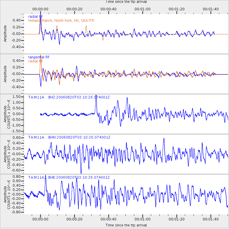
Signal To Noise
| Channel | StoN | STA | LTA |
| TA:M11A: :BHN:20060820T03:10:26.074001Z | 1.5089291 | 1.4041917E-7 | 9.305883E-8 |
| TA:M11A: :BHE:20060820T03:10:26.074001Z | 3.07645 | 2.859694E-7 | 9.2954345E-8 |
| TA:M11A: :BHZ:20060820T03:10:26.074001Z | 9.085866 | 5.396935E-7 | 5.9399234E-8 |
| Arrivals |
| Ps | 9.7 SECOND |
| PpPs | 29 SECOND |
| PsPs/PpSs | 39 SECOND |


