You are here: Home > Network List > TA - USArray Transportable Network (new EarthScope stations) Stations List
> Station F26K Sheenjek River, AK, USA > Earthquake Result Viewer
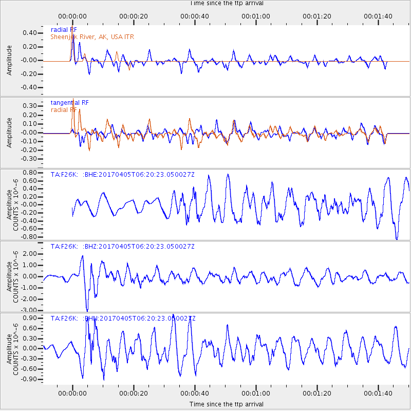
F26K Sheenjek River, AK, USA - Earthquake Result Viewer
*The percent match for this event was below the threshold and hence no stack was calculated.
| Earthquake location: |
Northern And Central Iran |
| Earthquake latitude/longitude: |
35.8/60.4 |
| Earthquake time(UTC): |
2017/04/05 (095) 06:09:12 GMT |
| Earthquake Depth: |
13 km |
| Earthquake Magnitude: |
6.1 Mww |
| Earthquake Catalog/Contributor: |
NEIC PDE/us |
|
| Network: |
TA USArray Transportable Network (new EarthScope stations) |
| Station: |
F26K Sheenjek River, AK, USA |
| Lat/Lon: |
67.69 N/144.15 W |
| Elevation: |
683 m |
|
| Distance: |
75.2 deg |
| Az: |
9.455 deg |
| Baz: |
339.523 deg |
| Ray Param: |
$rayparam |
*The percent match for this event was below the threshold and hence was not used in the summary stack. |
|
| Radial Match: |
55.784588 % |
| Radial Bump: |
331 |
| Transverse Match: |
53.08219 % |
| Transverse Bump: |
327 |
| SOD ConfigId: |
11737051 |
| Insert Time: |
2019-04-27 01:25:33.336 +0000 |
| GWidth: |
2.5 |
| Max Bumps: |
400 |
| Tol: |
0.001 |
|
Signal To Noise
| Channel | StoN | STA | LTA |
| TA:F26K: :BHZ:20170405T06:20:23.050027Z | 4.205497 | 1.147981E-6 | 2.7297156E-7 |
| TA:F26K: :BHN:20170405T06:20:23.050027Z | 1.5171007 | 4.209385E-7 | 2.7746245E-7 |
| TA:F26K: :BHE:20170405T06:20:23.050027Z | 1.4864836 | 2.1974083E-7 | 1.4782593E-7 |
| Arrivals |
| Ps | |
| PpPs | |
| PsPs/PpSs | |


