You are here: Home > Network List > TA - USArray Transportable Network (new EarthScope stations) Stations List
> Station I23K Minto, Yukon-Koyukuk, AK, USA > Earthquake Result Viewer
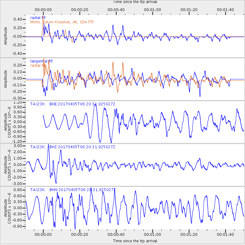
I23K Minto, Yukon-Koyukuk, AK, USA - Earthquake Result Viewer
*The percent match for this event was below the threshold and hence no stack was calculated.
| Earthquake location: |
Northern And Central Iran |
| Earthquake latitude/longitude: |
35.8/60.4 |
| Earthquake time(UTC): |
2017/04/05 (095) 06:09:12 GMT |
| Earthquake Depth: |
13 km |
| Earthquake Magnitude: |
6.1 Mww |
| Earthquake Catalog/Contributor: |
NEIC PDE/us |
|
| Network: |
TA USArray Transportable Network (new EarthScope stations) |
| Station: |
I23K Minto, Yukon-Koyukuk, AK, USA |
| Lat/Lon: |
65.15 N/149.36 W |
| Elevation: |
149 m |
|
| Distance: |
76.7 deg |
| Az: |
12.461 deg |
| Baz: |
335.477 deg |
| Ray Param: |
$rayparam |
*The percent match for this event was below the threshold and hence was not used in the summary stack. |
|
| Radial Match: |
66.81322 % |
| Radial Bump: |
400 |
| Transverse Match: |
59.51115 % |
| Transverse Bump: |
400 |
| SOD ConfigId: |
11737051 |
| Insert Time: |
2019-04-27 01:25:46.678 +0000 |
| GWidth: |
2.5 |
| Max Bumps: |
400 |
| Tol: |
0.001 |
|
Signal To Noise
| Channel | StoN | STA | LTA |
| TA:I23K: :BHZ:20170405T06:20:31.925027Z | 4.469161 | 1.3570732E-6 | 3.0365277E-7 |
| TA:I23K: :BHN:20170405T06:20:31.925027Z | 1.4132988 | 4.36638E-7 | 3.0894952E-7 |
| TA:I23K: :BHE:20170405T06:20:31.925027Z | 2.723065 | 8.0004565E-7 | 2.9380337E-7 |
| Arrivals |
| Ps | |
| PpPs | |
| PsPs/PpSs | |


