You are here: Home > Network List > TA - USArray Transportable Network (new EarthScope stations) Stations List
> Station M11A Holland Ranch, North Fork, NV, USA > Earthquake Result Viewer
M11A Holland Ranch, North Fork, NV, USA - Earthquake Result Viewer
| Earthquake location: |
Rat Islands, Aleutian Islands |
| Earthquake latitude/longitude: |
51.8/177.1 |
| Earthquake time(UTC): |
2006/06/14 (165) 04:18:42 GMT |
| Earthquake Depth: |
14 km |
| Earthquake Magnitude: |
5.9 MB, 6.4 MS, 6.4 MW, 6.4 MW |
| Earthquake Catalog/Contributor: |
WHDF/NEIC |
|
| Network: |
TA USArray Transportable Network (new EarthScope stations) |
| Station: |
M11A Holland Ranch, North Fork, NV, USA |
| Lat/Lon: |
41.43 N/115.79 W |
| Elevation: |
1849 m |
|
| Distance: |
45.7 deg |
| Az: |
75.371 deg |
| Baz: |
306.881 deg |
| Ray Param: |
0.071075715 |
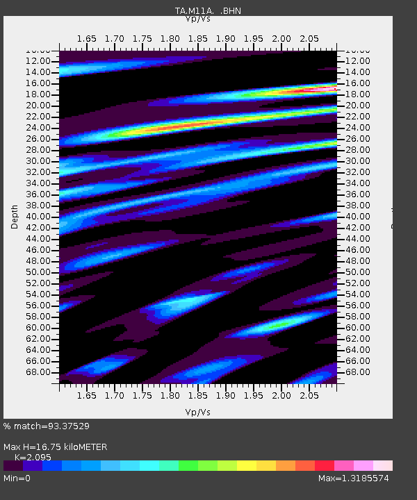
| Estimated Moho Depth: |
16.75 km |
| Estimated Crust Vp/Vs: |
2.10 |
| Assumed Crust Vp: |
6.276 km/s |
| Estimated Crust Vs: |
2.996 km/s |
| Estimated Crust Poisson's Ratio: |
0.35 |
|
| Radial Match: |
93.37529 % |
| Radial Bump: |
379 |
| Transverse Match: |
80.305595 % |
| Transverse Bump: |
400 |
| SOD ConfigId: |
5745 |
| Insert Time: |
2010-03-05 22:49:32.553 +0000 |
| GWidth: |
2.5 |
| Max Bumps: |
400 |
| Tol: |
0.001 |
|
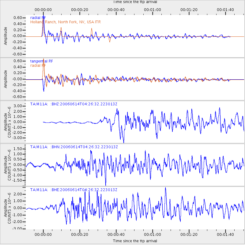
Signal To Noise
| Channel | StoN | STA | LTA |
| TA:M11A: :BHN:20060614T04:26:32.223013Z | 1.1708564 | 1.3433906E-7 | 1.14735734E-7 |
| TA:M11A: :BHE:20060614T04:26:32.223013Z | 3.661766 | 2.0986278E-7 | 5.73119E-8 |
| TA:M11A: :BHZ:20060614T04:26:32.223013Z | 6.4221463 | 4.981347E-7 | 7.756514E-8 |
| Arrivals |
| Ps | 3.1 SECOND |
| PpPs | 7.9 SECOND |
| PsPs/PpSs | 11 SECOND |


