You are here: Home > Network List > TA - USArray Transportable Network (new EarthScope stations) Stations List
> Station M11A Holland Ranch, North Fork, NV, USA > Earthquake Result Viewer
M11A Holland Ranch, North Fork, NV, USA - Earthquake Result Viewer
| Earthquake location: |
Fiji Islands Region |
| Earthquake latitude/longitude: |
-17.5/-178.7 |
| Earthquake time(UTC): |
2006/06/09 (160) 05:58:27 GMT |
| Earthquake Depth: |
564 km |
| Earthquake Magnitude: |
5.3 MB, 6.1 MW, 6.1 MW |
| Earthquake Catalog/Contributor: |
WHDF/NEIC |
|
| Network: |
TA USArray Transportable Network (new EarthScope stations) |
| Station: |
M11A Holland Ranch, North Fork, NV, USA |
| Lat/Lon: |
41.43 N/115.79 W |
| Elevation: |
1849 m |
|
| Distance: |
82.6 deg |
| Az: |
42.482 deg |
| Baz: |
238.976 deg |
| Ray Param: |
0.045106124 |
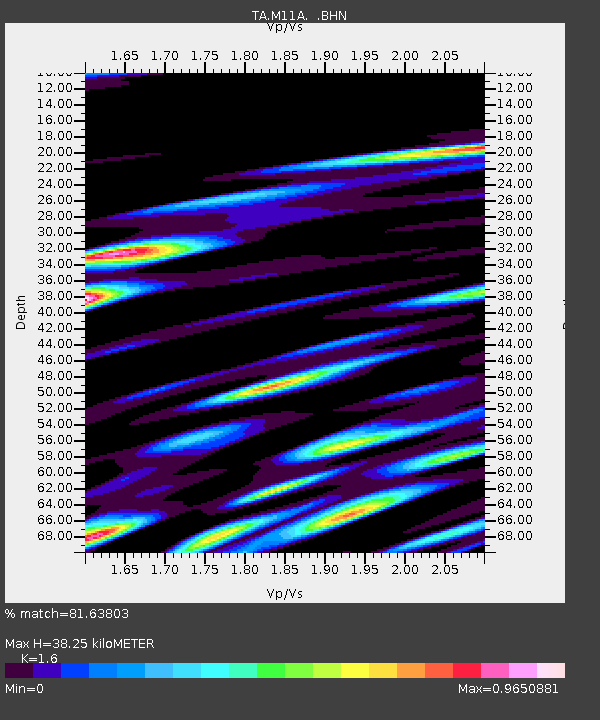
| Estimated Moho Depth: |
38.25 km |
| Estimated Crust Vp/Vs: |
1.60 |
| Assumed Crust Vp: |
6.276 km/s |
| Estimated Crust Vs: |
3.922 km/s |
| Estimated Crust Poisson's Ratio: |
0.18 |
|
| Radial Match: |
81.63803 % |
| Radial Bump: |
400 |
| Transverse Match: |
61.815086 % |
| Transverse Bump: |
400 |
| SOD ConfigId: |
2669 |
| Insert Time: |
2010-03-05 22:49:42.619 +0000 |
| GWidth: |
2.5 |
| Max Bumps: |
400 |
| Tol: |
0.001 |
|
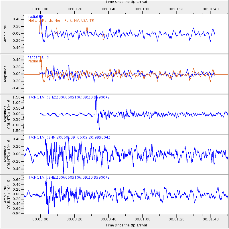
Signal To Noise
| Channel | StoN | STA | LTA |
| TA:M11A: :BHN:20060609T06:09:20.999004Z | 1.7747133 | 1.4813943E-7 | 8.347232E-8 |
| TA:M11A: :BHE:20060609T06:09:20.999004Z | 3.6755478 | 2.919306E-7 | 7.942506E-8 |
| TA:M11A: :BHZ:20060609T06:09:20.999004Z | 9.000398 | 6.8810067E-7 | 7.645225E-8 |
| Arrivals |
| Ps | 3.8 SECOND |
| PpPs | 15 SECOND |
| PsPs/PpSs | 19 SECOND |


