You are here: Home > Network List > TA - USArray Transportable Network (new EarthScope stations) Stations List
> Station M11A Holland Ranch, North Fork, NV, USA > Earthquake Result Viewer
M11A Holland Ranch, North Fork, NV, USA - Earthquake Result Viewer
| Earthquake location: |
New Britain Region, P.N.G. |
| Earthquake latitude/longitude: |
-5.7/151.1 |
| Earthquake time(UTC): |
2006/05/28 (148) 03:12:08 GMT |
| Earthquake Depth: |
34 km |
| Earthquake Magnitude: |
5.9 MB, 6.6 MS, 6.5 MW, 6.4 MW |
| Earthquake Catalog/Contributor: |
WHDF/NEIC |
|
| Network: |
TA USArray Transportable Network (new EarthScope stations) |
| Station: |
M11A Holland Ranch, North Fork, NV, USA |
| Lat/Lon: |
41.43 N/115.79 W |
| Elevation: |
1849 m |
|
| Distance: |
96.1 deg |
| Az: |
49.032 deg |
| Baz: |
267.735 deg |
| Ray Param: |
0.040603768 |
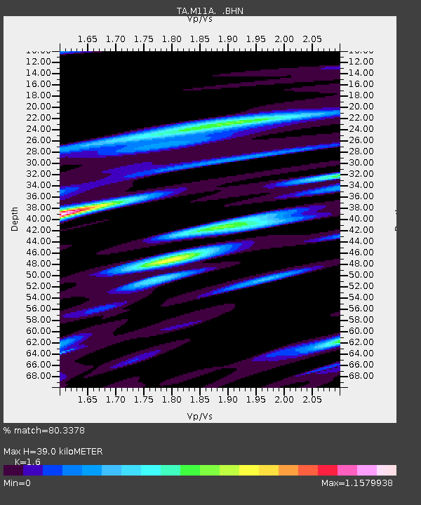
| Estimated Moho Depth: |
39.0 km |
| Estimated Crust Vp/Vs: |
1.60 |
| Assumed Crust Vp: |
6.276 km/s |
| Estimated Crust Vs: |
3.922 km/s |
| Estimated Crust Poisson's Ratio: |
0.18 |
|
| Radial Match: |
80.3378 % |
| Radial Bump: |
400 |
| Transverse Match: |
70.55936 % |
| Transverse Bump: |
400 |
| SOD ConfigId: |
2669 |
| Insert Time: |
2010-03-05 22:49:44.761 +0000 |
| GWidth: |
2.5 |
| Max Bumps: |
400 |
| Tol: |
0.001 |
|

Signal To Noise
| Channel | StoN | STA | LTA |
| TA:M11A: :BHN:20060528T03:25:01.249014Z | 1.2600608 | 1.1430881E-7 | 9.071691E-8 |
| TA:M11A: :BHE:20060528T03:25:01.249014Z | 3.1768775 | 2.868072E-7 | 9.027959E-8 |
| TA:M11A: :BHZ:20060528T03:25:01.249014Z | 10.261589 | 5.80588E-7 | 5.6578763E-8 |
| Arrivals |
| Ps | 3.8 SECOND |
| PpPs | 16 SECOND |
| PsPs/PpSs | 20 SECOND |


