You are here: Home > Network List > TA - USArray Transportable Network (new EarthScope stations) Stations List
> Station 121A Cookes Peak, Deming, NM, USA > Earthquake Result Viewer
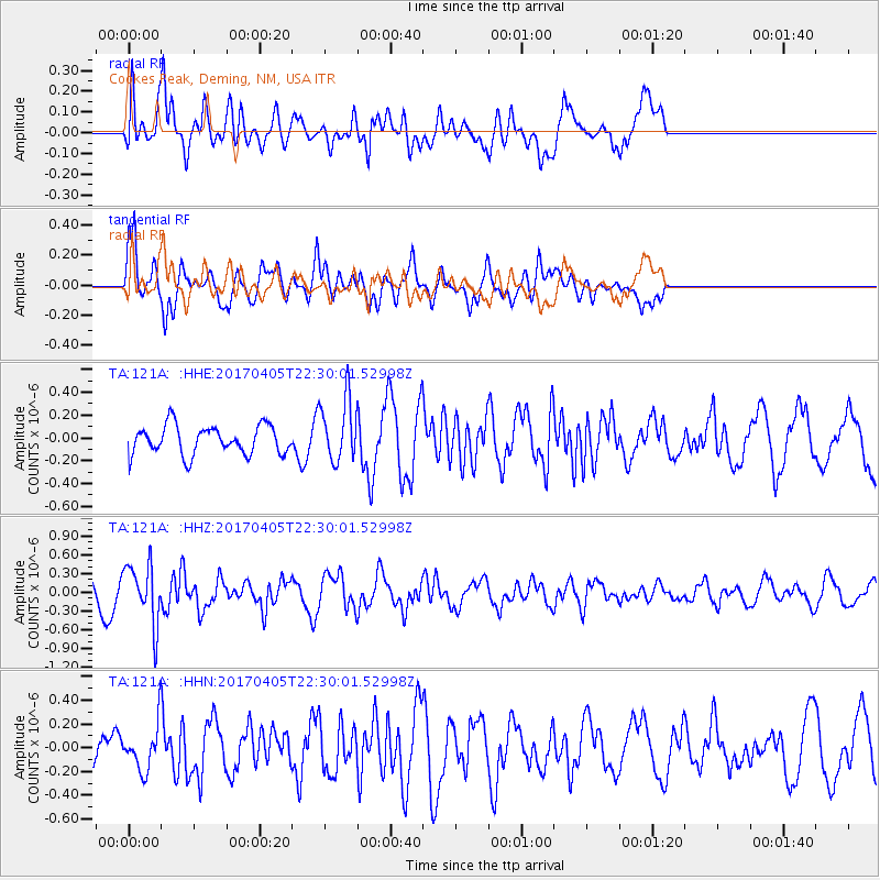
121A Cookes Peak, Deming, NM, USA - Earthquake Result Viewer
*The percent match for this event was below the threshold and hence no stack was calculated.
| Earthquake location: |
Vanuatu Islands |
| Earthquake latitude/longitude: |
-19.0/169.6 |
| Earthquake time(UTC): |
2017/04/05 (095) 22:17:42 GMT |
| Earthquake Depth: |
248 km |
| Earthquake Magnitude: |
5.6 Mww |
| Earthquake Catalog/Contributor: |
NEIC PDE/us |
|
| Network: |
TA USArray Transportable Network (new EarthScope stations) |
| Station: |
121A Cookes Peak, Deming, NM, USA |
| Lat/Lon: |
32.53 N/107.79 W |
| Elevation: |
1652 m |
|
| Distance: |
94.1 deg |
| Az: |
57.125 deg |
| Baz: |
250.187 deg |
| Ray Param: |
$rayparam |
*The percent match for this event was below the threshold and hence was not used in the summary stack. |
|
| Radial Match: |
63.966114 % |
| Radial Bump: |
400 |
| Transverse Match: |
60.700363 % |
| Transverse Bump: |
400 |
| SOD ConfigId: |
11737051 |
| Insert Time: |
2019-04-27 01:33:07.126 +0000 |
| GWidth: |
2.5 |
| Max Bumps: |
400 |
| Tol: |
0.001 |
|
Signal To Noise
| Channel | StoN | STA | LTA |
| TA:121A: :HHZ:20170405T22:30:01.52998Z | 2.0208337 | 4.7106147E-7 | 2.3310255E-7 |
| TA:121A: :HHN:20170405T22:30:01.52998Z | 0.5898039 | 1.831006E-7 | 3.104432E-7 |
| TA:121A: :HHE:20170405T22:30:01.52998Z | 2.1793015 | 2.762E-7 | 1.2673786E-7 |
| Arrivals |
| Ps | |
| PpPs | |
| PsPs/PpSs | |


